
by John Phillips, Naturalist at Croton Point Nature Center
Rock formations at Marshlands Conservancy can be observed up close in the forested areas of the park and along the salt marsh island beaches
The bedrock of Marshlands Conservancy is part of the Hartland Formation. A large scale geological zone of similar age which stretches from northwest Connecticut south to Long Island Sound. Marshlands’ bedrock is primarily schist, a metamorphic rock, meaning that the original rock structure has been altered and distorted by heat and pressure. Schist is normally full of glittering mica and fractures in sheets. Garnet crystals form in schists near contact zones such as southeastern New York State, and Rye’s public schools’ athletic teams take their name from the garnets that are found in local bedrock. Marshlands’ schists were formed in the Ordovician period, 485 MYA (Million Years Ago) to 444 MYA and are composed of metamorphosed seafloor sediments.
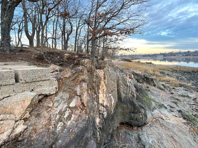
Photo: John Phillips
Hartland Schist exposure on Marie’s Neck at low tide
A 450 foot wide strip of amphibolite bedrock, also within the Hartland Formation, stretches from southwest to northeast along the steep slope above the salt marsh. Like Marshlands’ predominant schist the amphibolite here is likely of metamorphic origin, formed by heating and compression of an ancient seafloor. Amphibolite often has a “salt and pepper” appearance and is quite hard, which is why it remains as an erosion resistant ridge above Milton Harbor. Amphibolite is often quarried as a building stone.
Marshlands surface landscape was radically re-arranged at the end of the Pleistocene Epoch by a vast ice sheet which 20,000 years ago to 16,000 years ago, mere nanoseconds on the earth’s geological clock. This most recent glaciation covered New York State with an ice sheet thousands of feet thick in Hartland Schist exposure on Marie’s Neck at low tide – John Phillips some places, which scraped down and redistributed the local bedrock while also importing rock debris from further north, leaving us the landscape we see today.
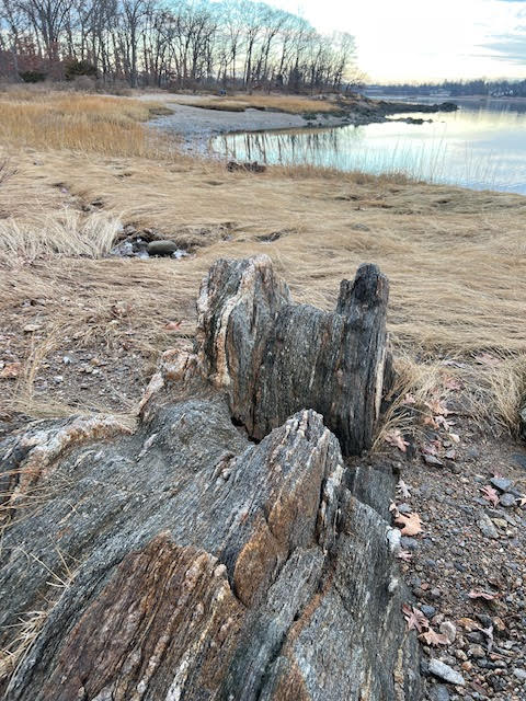
Photo: ©John Phillips
Schist exposure at low tide showing schistose, or foliated (sheet-like) structure
The Origins of Marshlands Bedrock
The origins of Marshlands bedrock stretch back to the Paleozoic Era when the oceans and continents of planet earth were in completely different locations and configurations than today. The story of North America’s east Coast over the past 500 million years is one of continental collisions forcing up mountain ranges which slowly erode to sea level or below, then are lifted back up again during subsequent continental collisions. It’s hard to imagine that during the earth’s recent history three major mountain building events (orogenies) have transformed the place we live. The Taconic Orogeny, before animal life on land; the Acadian Orogeny, when early amphibians and trees appear; and the Alleghenian Orogeny when reptiles first evolved, were all followed by the erosion and diminution of these mountain ranges, leaving traces of each in today’s uplifted and gently rolling Appalachians. These cycles each took close to a hundred million years, and had a profound influence on the geology and geography of what we now call the east coast of North America. For Marshlands the most significant of these events at was the Taconic Orogeny in the Ordovician Period.
During the Ordovician there were only a few primitive plants colonizing the land but the oceans and seas were full of life including many species of corals, graptolites, brachiopods, trilobites, and cephalopods, most now extinct but known from fossils in ancient rocks which preserve their remains. This chapter in the earth’s history lasted for about 41 million years.
Earth’s solid outermost layer is assembled of enormous continental plates which drift slowly on top of the asthenosphere, a deep, partially molten layer of rock
At present the North American continental plate (in the Ordovician termed the Laurentian Plate) is pulling away from the African continental plate at a rate of about 1 inch per year as the Atlantic Ocean widens
During the Ordovician Period however, the proto Atlantic Ocean was shrinking, as a collision with the distant Baltica continental plate pushed seafloor west over the Laurentian Plate, forcing it down into the asthenosphere. The intense pressure and heat where the plates collided cracked (faulted) the earth’s crust allowing magma to rise and creating a chain of volcanic islands which moved steadily west, crushing, metamorphosing and welding rock from the ancient seafloor to the eastern edge of Laurentia. The enormous pressure on eastern Laurentia’s continental margin pushed far inland, folding, faulting and raising a vast mountain range as high as the Rockies, stretching from Canada to Georgia. Today the deeply eroded roots of these mountains recline along New York State’s eastern border from Vermont to Connecticut. We call them the Taconics.
Marshlands schist is composed of seafloor sediments
These sediments are primarily erosional mud and silt trapped between the Laurentian continental plate and the approaching volcanic island arc. The seafloor muds and silts were deeply buried over time and underwent diagenetic change via compaction (settling), and mineralization (interaction with heat and water), completing the metamorphosis into the glittery, brittle rock we see today.
Along with the schist an amphibolite belt was formed by the same processes as the schist, however amphibolite has different parent rock than schist. Marshland’s amphibolite most likely formed from a zone of dolomite-calcite rich rock originating as seafloor sediments composed of the skeletons of marine organisms rather than non-organic muds and silts which compose schist.
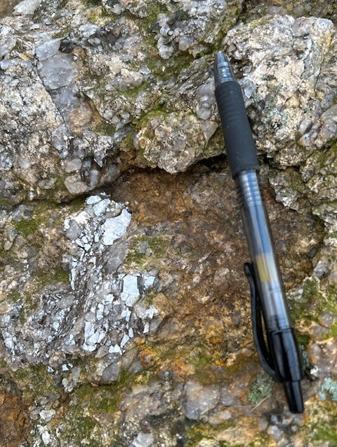
Photo: ©John Phillips
Detail of schist: reflective Muscovite Mica left center, quartz vein upper left. Pen for scale 5.5 inches
If you were at the shore of Marshlands 20,000 years ago, the blink of an eye in geologic time, you would be standing on as much as a thousand of feet of solid ice which stretched from the north pole to Long Island
This was the maximum ice advance of the most recent Pleistocene glaciation, known as the Wisconsin Glacial Episode. Milton Harbor and Long Island Sound were also covered by the deep ice, and Long Island was invisible, a ridge of mixed boulders, smaller rocks and sediments dumped at the foot of the farthest edge of the ice sheet. The Atlantic Ocean was over thirty miles beyond that because the glaciation tied up enough water to drop sea levels drastically, exposing huge parts of the continental shelf that are now drowned. There was so much ice on the land that it’s weight pushed the continental crust down!
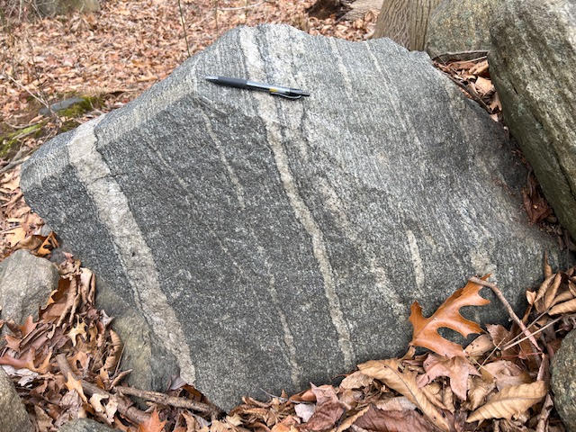
Photo: ©John Phillips
Amphibolite boulder with quartz veins in stone wall bordering field. Pen for scale 5.5 inches
The glacier bulldozed the entire northeast, scraping away forests, soils, and the bedrock itself
Piles of debris left by the glacier are called moraines, and Long Island is where the glacial bulldozer stopped, leaving a high terminal moraine of mixed clay, silt, sand, pebbles, rocks, and boulders. When the glacier began to melt it receded northward, releasing torrents of water along with debris it was carrying, carving deep river channels, forming enormous impounded lakes and piling sand, gravel and rocks in valleys. North of the terminal moraine the landscape was completely changed.
At Marshlands there is little obvious evidence of this tumultuous recent event. But under close observation you can see it in the stone walls that run through the woods, built by the colonists. Most of these rocks in the stone walls are local schist but many are not local and may come from many miles to the north. The high outcrop ledges above Milton Harbor are composed of amphibolite, which is harder than the surrounding schist, standing higher because it is more resistant to glacial scouring. Other signs of glaciation are the many ice scattered rocks and boulders that stud the forest floor.
Crashing continents! Towering mountain rise then vanish! A world deep under ice! These incredible geological episodes can all be perceived in Marshlands’ landscape, just a few of the many natural wonders to observe here!
Sources
Borst, Roger L. Rocks and Minerals of New York State. Educational Leaflet Number 10, S.U.N.Y. Albany, New York State Museum and Science Service, Albany, New York, 1960.
Finks, R.M. Taconian Islands and the shores of Appalachia: Guide Book to Field Excursions. 40th Annual Meeting of the New York Geological Association, 1968.
Hall, L.M. Bedrock Geology in the Vicinity of White Plains, New York: Guide Book to Field Excursions. 40th Annual Meeting of the New York Geological Association, 1968.
Isachsen, Y.W., Landing, E., Lauber, J.M., Rickard, L.V., Rogers, W.B. Geology of New York, A Simplified Account. New York State Museum/Geological Survey, S.U.N.Y. Albany, 1991.
Jaret, S.J., Tailby, N.D., Hammond, K.G., Rasbury, E.T., Wooton, K., Ebel, D.S., DiPadova, E., Smith, R., Yuan, V., Jaffe, N., Smith, L.M., Spaeth, L. Geology of Central Park, Manhattan USA: New Geochemical Insights. Geological Society of America, FieldGuide 61, 2021.
Kulick, S., Salmansohn, P., Schmidt, M., Welch, H. The Audubon Society Field Guide to the Natural Places of the Northeast:Coastal. Hilltown Press Inc, Pantheon Press, N.Y., 1984.
McGuire, Thomas. 10 (9) Years: A Guide to the Geology of Westchester County, New York. Special Publication #10, Rochester Mineralogical Symposium, Rochester, New York, 1991.
Pellegrini, Thomas. Bedrock Geology of the Mamaroneck Quadrangle, N.Y. (Map). New York State Museum and Science Service Map and Chart Series Number 29, S.U.N.Y. Albany, 1977.
Raymo, C., Raymo, M. Written in Stone, A Geological History of the Northeastern United States. Black Dome Press Corp, Hensonville, New York, 2007.
Schimmrich, S. Geology of the Hudson Valley, A Billion Years of History. Independently Published, 2020.
Seyfert, C.K., Leveson, D.J. Structure and Petrology of Pelham Bay Park: Guide Book to Field Excursions. 40th Annual Meeting of the New York Geological Association, 1968.
Van Diver, Bradford B. Roadside Geology of New York. Mountain Press Publishing Company, Missoula, Montana, 1992