
Paleoindians
Some archaeologists believe that humans had already entered North America by about 15,000 years ago, but the evidence of arrival before ca. 13,500 cal BP remains incoherent and unpersuasive. In Orange County, in southeastern New York, a sequence of environmental changes dated to ca. 14,000 cal BP hints at an earlier human presence: spores of the dung-dependent Sporormiella fungus decrease sharply, followed by a charcoal influx and a marked vegetation change. These proxies seem to manifest a decline of mastodont and other megafauna, plausibly attributed to human predation (Robinson et al. 2005); however, radiocarbon-dated bones and tusks show that mastodont persisted in southern New York until ca. 13,000 cal BP or even several centuries later (Feranec and Kozlowski 2012; Fiedel 2018).
The first well-attested and ubiquitous cultural tradition across the continent is Clovis, with earliest dates of ca. 13,500 cal BP. Paleoindians using Clovis spearpoints arrived in the Mid-Atlantic region ca. 13,000 cal BP. These fluted points were often made of high-quality cryptocrystalline stone. Many have been found, with few or no associated artifacts, on the surfaces of fields. Buried, stratified Paleoindian sites are very rare.
Classic Clovis fluted points resembling those from the Plains and Southwest have been found in eastern Pennsylvania and eastern New York. South of Albany, several Paleoindian sites in Greene County (Kings Road, Swale, West Athens Hill) show that the Normanskill chert sources of this area attracted early quarrying and camping (Funk 2004). Juliet Morrow (personal communication 2016) has recently examined artifacts from the Greene County sites and confirms that they include early Clovis-style bifaces.
However, Clovis points appear to be absent from, or very rare, east of the Hudson in New England. The pioneering Paleoindians of this region made fluted points that resemble the Gainey type of the northern Midwest. Few secure radiocarbon dates are associated with Gainey points, but the minor stylistic differences from the ancestral Clovis form suggest a date of ca. 12,800 to 12,600 cal BP. The Paleoindians arrived in New England just at the onset of the Younger Dryas cold period, which lasted from 12,850 to 11,650 cal BP. Because of a radiocarbon plateau during this period, radiocarbon dates are of limited use in seriating the proposed stylistic phases. Available dates associated with fluted points in New England fall in the range of 10,700-10,200 rcbp (12,700-11,800 cal BP). Lacking reliable dates, archaeologists have relied on small stylistic differences to assign relative dates to surface-found fluted points.
Across a vast area the stylistic trends among point-makers descended from Clovis are similar—the channels or flutes become longer, a discrete nipple at the base of the preform is isolated and used to detach the long fluting flake, and the base becomes more concave. In the northern Midwest, this trend leads to the Barnes/Parkhill type that follows Gainey. In New England, a suggested stylistic sequence (Lothrop and Bradley 2012) begins with King’s Road/Whipple (Gainey-like), followed by the Vail/Debert points with very deep basal concavities (which lack obvious Great Lakes counterparts). Next are Bull Brook/West Athens Hill points, followed by Michaud/Neponset (equivalent to Barnes). These are followed by the last fluted point type, Crowfield (ca. 12,200 to 11,600 cal BP). Small unfluted points called Cormier/Nicholas are the New England equivalent of the Holcombe type of Michigan (ca. 11,600 cal BP). Long, unfluted points that resemble the Agate Basin type of the Plains are sparsely distributed in New England; some also were found at the Plenge Site in northern New Jersey. These date to about 11,800 to 11,000 cal BP.
Notable Paleoindian sites have been found in Connecticut (Templeton and Jones sites), southeastern New York (Dutchess Quarry Cave, Twin Fields, Port Mobil), northern New Jersey (Plenge), and eastern Pennsylvania (Shawnee-Minisink).
At Dutchess Quarry Cave 1, near the village of Florida in Orange County, New York, a Cumberland-like fluted point, with flutes extending along nearly the entire length of the point, was found in the same stratum as fragments of caribou bone. A radiocarbon date of 12,530±370 rcbp (ca. 13,800-16,000 cal BP) was obtained from the bones (Funk et al. 1970). At first, this date was thought to be applicable also to the Paleoindian point, although it was markedly earlier than other dates for fluted point assemblages. In fact, the Cumberland style appears to be rather late (ca. 12,500 cal BP). It was shown subsequently that the early date is accurate, but is associated only with the extirpated Pleistocene fauna, not with the subsequent human occupation of the cave (Steadman et al. 1996). Three additional fluted point fragments, again Cumberland-like, were found in disturbed contexts in Dutchess Quarry Cave 8 (Kopper et al. 1980), 12 meters north of Dutchess Quarry Cave 1. Lothrop and Bradley (2012) ascribe these points to the Michaud/Neponset style. Small corner-notched points recovered from this cave are probably examples of the Early Archaic Amos type, dating from circa 11,500 to 10,300 cal BP.
Shawnee-Minisink is a multi-component, deeply stratified site located in Monroe County, Pennsylvania, at the confluence of the Delaware River and Brodhead Creek. A hearth found at the lowest level, associated with Paleoindian artifacts (two Clovis points and numerous endscrapers) produced radiocarbon dates on burnt seeds; these average 10,940±15 rcbp (about 12,850 cal BP) (Gingerich 2007, 2011, 2013). Shawnee-Minisink is currently the most precisely dated Paleoindian site in North America (Waters and Stafford 2007; Waters et al. 2020). The hearth contained evidence of a broad-spectrum diet: seeds and pits of acalypha, blackberry, hackberry, hawthorn plum, and grape, as well as hickory nuts (Dent 1991:125). The Paleoindian camp’s setting is reconstructed as a grassy open patch amid a pine and birch-dominated woodland.
Twin Fields is located on a sandy bluff above the Dwaar Kill, near Wallkill in Ulster County, New York. Two fragments of fluted points and numerous unifacial tools were recognized in a mixed assemblage from near-surface soils (Eisenberg 1978:79). The abundance of scrapers here suggests a specialized wood-working camp.
Numerous fluted points of both early and late styles, and a few unfluted Plano-like points, were collected from the surface of the Plenge site in New Jersey (Kraft 1973; Gingerich 2013). Fluted points were found near the Arthur Kill on Staten Island at the Port Mobil Site (Kraft 1977).
A fluted point of the Michaud/Neponset style, fluting or “channel flakes,” and other Paleoindian artifacts were found at the Templeton site (6LF21) in Washington, CT. The predominant material was chert from the Hudson Valley. An associated radiocarbon date was 10,190+-300 rcbp (Moeller 1980).
A buried Paleoindian site, named in honor of the late State Archaeologist Brian D. Jones, was recently discovered beside the Farmington River in Avon, CT. Pine charcoal from a hearth has been dated to 10,520 ± 30 rcbp (12,630-12,500 cal BP) (Leslie et al. 2020). Many tools have been recovered, but only one fluted point base, which appears to be of the Bull Brook type.
Experiments with replica points, mounted on spears and thrown using an atlatl, have demonstrated that fluted points were well designed to penetrate elephant hide; their use in hunting of mammoths is amply evidenced at a dozen kill sites in the Plains and Southwest. A few Clovis points were found in loose association with mastodont (Mammut americanum) skeletons at the Kimmswick site near St. Louis; however, no clear evidence of hunting or butchering of mastodonts or other terminal Pleistocene megafauna has been found at any other site east of the Mississippi. Instead, the few tiny preserved bone fragments that have been recovered from eastern Paleoindian sites represent still extant species that have moved north during the Holocene, such as caribou and Arctic fox. Along with the evidence of fruit-harvesting at Shawnee-Minisink, the absence of kill sites has led many archeologists to conclude that megafauna had mostly vanished from the Middle Atlantic region by the time Paleoindians arrived (e.g., Dent 1991, Boulanger and Lyman 2014).
The question of human-mastodont temporal and behavioral association is particularly relevant because the greatest concentration of mastodont fossils in the Northeast is located in Orange County, NY. Ritchie (1965:9) speculated that evidence of Paleoindian predation on megafauna might be found nearby in the Wallkill River Valley or the Black Dirt, which is drained by the Wallkill. Dutchess Quarry Cave, it may be noted, looks out over the Black Dirt, which had already become a bog by the time of Paleoindian occupation. Several radiocarbon dates for Orange County mastodonts have placed them late enough to have encountered human predators, e.g., 9860±225 rcbp for the Sugar Loaf specimen, and 10,000±160 rcbp for the Arborio mastodont, found in a bog south of Montgomery (Dumont and Ehlers 1973). A bone from another extinct species, the stag-moose Cervalces scotti found at the Dewey-Parr site in Orange County, produced a Clovis-era date of 10,950±150 rcbp (I-4016) (Funk et al. 1970). Bone has always been a notoriously difficult material for radiocarbon dating, however, and unrecognized contaminants often result in dates that are obviously too recent. These dates obtained in the 1970s may reflect such problems. New procedures for extraction of pure collagen from ancient bone seem to yield more credible dates, which are usually older than those previously obtained from the same samples. For instance, a new date for the Arborio specimen is 11,750+-60 rcbp (about 13,600 cal BP) (Feranec and Kozlowski 2012). Nevertheless, recent dates still place many mastodonts late enough to overlap with the earliest Paleoindians in the region. Another Orange County find, the Temple Hill mastodont, has been dated to 11,000±80 rcbp (Robinson et al. 2005) and 10,900+-40 rcbp (Feranec and Kozlowski 2012). The Otisville mastodont yielded a date of 10,970±40 rcbp (Robinson et al. 2005) and a mastodont from Ellenville (Ulster County) has been dated to 10,850+-45 rcbp (Feranec and Kozlowski 2012, 2016). The Cohoes mastodont dates to 11,070+-60 rcbp. The Chittenango mammoth from Madison County has been dated to 11,250+-65 rcbp, and a mammoth from Watkins Glen in Schuyler County dates to 10,890+-50 rcbp. If a date on tooth-derived collagen is accurate, the Randolph mammoth from Cattaraugus County died ca. 10350+-45 rcbp (Boulanger and Lyman 2014). Apparently reliable dates for mastodont bones from the Hiscock Site in western New York include 10,850±140, 10,790±70, 10,705±80, and 10,630±80 rcbp (Laub 2003). Six fluted points and other Paleoindian tools have been found at Hiscock but not in close association with the mastodon remains. Note that these dates are statistically indistinguishable from those obtained for the Paleoindian occupation of Shawnee-Minisink (averaging 10,940±15 rcbp).
Finds of mastodont remains are relatively rare east of the Hudson River, but there are enough to demonstrate that they were living in southern New England and adjacent southeastern New York shortly before the arrival of Paleoindians (Fiedel et al. 2019). Of particular interest, with respect to the Marshlands, is the reported discovery in 1906 of a tooth and some small bone fragments on the property of William H. Fish in Hartsdale (Clarke 1908). Fish had a mansion called “The Grange,” located in what is now Scarsdale, on Mamaroneck Road. Mastodont teeth and tusks were found in Queens, northern Manhattan, and the Bronx in the 19th and early 20th centuries (Horenstein 2008). It is also noteworthy that several mastodont and mammoth teeth dated to ca. 13,000 cal BP have been dredged up in the Gulf of Maine (Claesson et al. 2017). Teeth of both mammoths and mastodonts have been brought up from the submerged continental shelf south of the Hudson River mouth, but none have been radiocarbon-dated (Whitmore et al. 1967).
Megafaunal extinction occurred across the continent coincident with both human arrival and the abrupt onset of the Younger Dryas. Paul Martin argued since the 1960s (Martin 2005) that human predation was primarily responsible for the simultaneous extinction of 32 genera of North American megamammals at 13,000-12,700 cal BP. Paradoxically, the extinction was so rapid—only some 400 years of overlap of the last megafauna and the first Paleoindians—that one should not expect to find many preserved kill and butchery sites (Fiedel and Haynes 2004; Fiedel 2009).
In New England, bone preservation is generally poor. The very limited faunal evidence suggests that caribou hunting was an important Paleoindian activity. Caribou foot bones have been recovered from Whipple in New Hampshire and Bull Brook in eastern Massachusetts; beaver bone was also recognized at the latter site. Small fragments of caribou and otter bone are reported from Tenant Swamp in New Hampshire (Goodby et al. 2014). Dincauze and Jacobson (2001) suggest that Paleoindians were attracted to the shores of proglacial lakes in northern New England by migratory waterfowl. McWeeney (2006) proposes a role for plants in the Paleoindian diet, noting the presence of a roasted water lily seed at the Jefferson Site in New Hampshire and hazelnut shell (directly dated to 10,260±70 rcbp) at the Hidden Creek Site in Connecticut. Hawthorn plum seeds and other fruit remains were recovered from Paleoindian hearths at the Shawnee-Minisink site (Dent 1985; Gingerich 2011).
Several Paleoindian points have been found by collectors in western Long Island (Saxon 1973). These surface finds might reflect waterborne voyages by Paleoindians across the placid waters of the Sound; alternatively, if Vanderkamp et al. (2005) are correct, the Sound may have been dry land, still crossable on foot at 12,500 cal BP.
At the Marshlands Conservancy, a possible fluted point collected by Wilbur Clark was reported by Birgit Morse. One point base in Stuart Fiedel’s collection may be a fragment of a small fluted point. Although it appears to be made of a lustrous black chert, it seems that this artifact actually was made of yellow Pennsylvania jasper that was turned black by a chemical reaction with sulfides as it lay in brackish water (Lowery and Wagner 2012).
Early Archaic and Middle Archaic Cultures
Although the megafauna seem to have been extinct by 12,600 cal BP, the use of fluted points continued for another thousand years. Perhaps they had proven effective in the pursuit of caribou, which may have lingered in the cold conifer-dominated forests of the Younger Dryas period. From Pennsylvania southward, the dramatic warming at the Holocene onset was coincident with a shift from fluted points to notched dart or knife forms (Kessell, Kirk/Palmer, Hardaway) that mark the start of a distinct cultural era, the Early Archaic, at ca. 11,500 cal BP;
The style change is evident at Shawnee-Minisink, where a single side-notched “Kline” point was recovered from the “Early Early Archaic” level, estimated to date to about 11,500 cal BP (McNett 1985). This point bears some resemblance to the Early Archaic St. Charles type of the Midwest. The only reported find of similar points in the Northeast is the discovery of four at a workshop site (194-3-1) located near West Athens, NY during a survey for the Iroquois Pipeline (Funk 1996:15).
Robert Funk (1996) observed the dearth of both Early and Middle Archaic sites and surface-collected diagnostic artifacts in the Northeast. The “Ritchie-Fitting” hypothesis (Fitting 1970; Ritchie 1971a) attributed the near-absence of cultural remains of these periods to the regional prevalence of a closed boreal forest that offered few resources for human foragers. Subsequent paleoecological research has shown that oaks and other deciduous trees colonized the region earlier than had been thought, and several deeply buried Early Archaic sites have been discovered (e.g., Johnsen No. 3 and Russ on the upper Susquehanna) (Funk 1993). Nevertheless, the paucity of Early and Middle Archaic diagnostics and components has not changed substantially and must be explained, probably in terms of paleoclimate or vegetation.
Corner-notched points of the Kirk series, dated to circa 9500-8500 rcbp (10,800-9600 cal BP) in the South, are very rare from New Jersey northward. At the Rockelein Site on the upper Delaware, near the Orange County border, a Kirk-like assemblage was radiocarbon-dated to 7520±120 rcbp (8400 cal BP) (Dumont and Dumont 1979). This date is anomalously late in comparison to southern dates for this type. The same site also yielded points of the LeCroy bifurcate, Eva, and Stanly/Neville types, indicating subsequent occupations between 8500 and 7000 rcbp (9600-7900 cal BP).
Early Archaic and early Middle Archaic points (Hardaway Side-Notched, Kirk/Palmer Corner-Notched, Kirk Stemmed, LeCroy bifurcates, Kanawha, Stanly/Neville) have been reported from several sites on Staten Island, including Old Place, Ward’s Point, and Richmond Hill. The deepest levels at Ward’s Point, evidently containing a mixture of several cultural components, were radiocarbon-dated to 8250±140 rcbp and 7260±125 rcbp. A Kirk/Palmer component at Richmond Hill yielded a date of 9360±120 rcbp (ca. 10,600 cal BP) (Ritchie and Funk 1973:38-39).
However, these early notched points are extremely rare in New England. Instead, from about 11,600 to 10,000 cal BP, New England seems to have been sparsely occupied by foragers using parallel-flaked spearpoints similar to the Plano points of the northern Plains (Sanger et al. 1992). At Varney Farm in Maine, a single component of this culture was dated to 9400 to 8400 rcbp (10,600-9400 cal BP) (Petersen et al. 2000).
The relationship, if any, between this Plano-like horizon and the contemporaneous riverine adaptation of the Gulf of Maine Archaic tradition, revealed by deep excavations in Maine (e.g., at the Sharrow Site on the Penobscot), is unclear (Petersen 1991; Petersen and Putnam 1992; Robinson 1992). These sites contain crude quartz scrapers and groundstone tools (full-channeled gouges and rods), but no projectile points. This same tradition seems to be manifest at the Eddy Site in New Hampshire (Bunker 1992) and in Connecticut at the Sandy Hill Site, located 150 meters (492 feet) north of the Hidden Creek Site on the Mashantucket Pequot Reservation. Subsistence remains at Sandy Hill include charred hazelnut shells and cattails. Blackened sand in depressions indicates the presence of semi-subterranean pithouses. Associated radiocarbon dates for Sandy Hill cluster around 8650 rcbp (9600 cal BP), with a range from 9340±60 to 8510±60 rcbp (10,500-9500 cal BP) (Jones and Forrest 2003).
At the Turkey Swamp site in northern New Jersey, lanceolate points were found in a buried context with associated radiocarbon dates ranging from 8740±165 to 7660±325 rcbp (about 10,000-9,000 cal BP) (Cavallo 1981). It is unclear how this assemblage relates to contemporary cultures.
In the Middle Atlantic region, bifurcate points are currently interpreted as diagnostic of the inception of a new period, the Middle Archaic (8500 to 5500 rcbp, 9600-6300 cal BP). This period roughly corresponds to the Hypsithermal climatic period, a warm, dry period when the oak-chestnut-deer-turkey biome became established in much of the Northeast. The warmest temperatures of the entire Holocene (in Greenland at least, if not everywhere in the Northern Hemisphere) actually occurred at the beginning of this period, around 10,000-9500 cal BP (Lecavalier et al. 2017).
People who made bifurcate-based points migrated from the Southeast into southern New England around 8500 rcbp (9500 cal BP). In the lower Connecticut River valley numerous bifurcates were found at the Dill Farm Site in East Haddam, Connecticut. An associated feature containing carbonized hazelnut and walnut shells was dated to 8560±270 rcbp (ca. 9500 cal BP) (Pfeiffer 1986). In eastern Massachusetts, finds of bifurcates are concentrated along the upper Taunton River in the Titicut area of North Middleboro and Bridgewater (Johnson 1993; Taylor 1976, 2005).
The near-contemporaneity of bifurcate points and the non-bifacial quartz assemblages of the Gulf of Maine Archaic sites suggests three alternative interpretations: (1) bifurcate makers spread northward as the range of the Gulf of Maine Archaic contracted, (2) populations of two distinct traditions and adaptations somehow co-existed for centuries by partitioning the landscape, or (3) the assemblages without bifaces represent some special task-, season-, or gender-specific facies of the bifurcate makers’ settlement system (Lavin 2013:70).
A mortuary site dated to ca. 9500 cal BP (8490±60, 8490±70, and 8260±70 rcbp), which must be related to one or another of these cultural complexes, was found at Table Land in Manchester, New Hampshire. An ochre-stained pit contained multiple deposits of calcined human bone accompanied by groundstone rods measuring 14 to 36 centimeters in length, three bifaces, and faceted pieces of hematite. The Morrill’s Point Mound burials in Manchester have recently been re-dated to 8500±80 and 8150±80 rcbp (Robinson 1996). These burials contained red ocher, groundstone gouges, rods, and serrated projectile points. Feature 206 at the Wapanucket Site in Middleborough, Massachusetts, previously assumed to be Late Archaic, has also been re-dated (8670±85 and 8610±80 rcbp, ca. 9600 cal BP) (Robinson 1996). This feature contained adzes or gouges and pieces of hematite.
In the Southeast, bifurcate points developed into Kanawha and very similar Stanly points ca. 7800 rcbp (8600 cal BP). In the Northeast, the Stanly equivalent is the Neville point, named for the site on the Merrimack River in Manchester, New Hampshire, where they were first recognized (Dincauze 1976). Radiocarbon dates from Neville and the Eddy Site, located on the opposite bank of the river, range from ca. 7800-7100 rcbp (8600-7900 cal BP) (Kenyon 1986:4). At Annasnappet Pond in Carver, Massachusetts, Neville points were associated with features, including red ochre-stained burial pits, dated between 7210±70 and 7880±240 rcbp (ca. 8700-8000 cal BP). Doucette (2005:27-28) notes that “Almost every category of tool that has been identified with the Gulf of Maine tradition has also been recovered from Annasnappet Pond, except for maritime related implements….Similar artifacts from Annasnappet Pond include ground stone rods, whetstones, quartz scrapers, pestles, axes, gouges, hematite and graphite paintstones, and, of course, red ochre pit features.” The spectacular whale-tail-shaped bannerstones (atlatl weights) are also noteworthy.
A rare occurrence of bifurcate points in the Mid-Hudson region was reported from the Haviland site, located near Cobleskill (Ferguson 1995). Charcoal loosely associated with the artifacts was dated to 8405+-65 rcbp (9400 cal BP). Several points found here most closely resemble the Kanawha type; another point seems to be a miniature Neville. Numerous pointed, thin ovate preforms or knives, and many utilized flakes, were recovered at the Haviland site.
At the Rockelein Site on the Delaware, the Neville-Stanly component included pitted stones, anvils, milling stones, and netsinkers. On the middle Delaware, nut-harvesting is attested at the Sandts Eddy site (north of Easton), where burnt hazelnut shells in Level IX were radiocarbon-dated to 7330+60 rcbp (8200 cal BP) (Bergman et al. 1994). The underlying occupation level (XI) yielded a LeCroy bifurcate point and an anomalous radiocarbon date of 9420±90 rcbp (10,700 cal BP), too early for this type.
A substantial Middle Archaic occupation is attested in the Mohonk Rockshelter, located on a ridge west of the Wallkill Valley in Ulster County, NY. A total of 73 Neville points were found here, as well as four very similar points ascribed to the Kanawha bifurcate type (Eisenberg 1991). The rockshelter deposits were entirely mixed, so no stratigraphic associations were observed.
In the Southeast, Stanly points are followed by convergent-stemmed Morrow Mountain points (Coe 1964). Although some regard the transition as gradual, Coe thought the stylistic change was abrupt and signaled the arrival of a new intrusive population. Sassaman (2010) agrees and suggests that the intruders, who also began collecting mussels from the rivers of the mid-South, may have migrated from the Columbia Plateau. In the Northeast, the Neville to Stark transition around 7200 rcbp (8000 cal BP) does not seem abrupt, in part because use-modified Neville points lost their crisp basal outlines and thus came to resemble rounded-base Starks (Cross 1999). These points are generally made of different lithic materials, however, even when they occur on the same sites. At Annasnappet Pond, the Neville points are rhyolite and the Stark points are quartz, quartzite, felsite, argillite, and indurated shale. In a cluster of Middle Archaic sites near upper Narragansett Bay in Rhode Island, the Nevilles are made of quartzite or, rarely, felsite, and Starks are of argillite (Rainey 2005). At one of these sites, Seekonk 2, a hearth was dated to 7240+-110 rcbp; both Neville and Stark points were found nearby. Fiedel (2014) proposes that an abrupt transition from Neville to Stark/Morrow Mountain may reflect regional environmental and social changes caused by the 8200 cal BP (7400 rcbp) cold event—the most dramatic climate downturn in the Holocene.
Whatever the actual genesis of the Morrow Mountain/Stark type, a major change in settlement patterns is evident in New England after the 8200 cal BP climate event, as groups shifted away from large interior wetlands. For example, the fringes of Cedar Swamp, on the Mashantucket Pequot Reservation in Connecticut, seem to have been “nearly devoid of a regular human presence” after 7500 rcbp (8300 cal BP), as inferred from the scarcity of Stark, Morrow Mountain I, and Merrimack stemmed points (Jones 1999).
The latter part of the Middle Archaic, ca. 7000 to 5500 rcbp (7900-6400 cal BP), is not well attested in this region. Diagnostic points of this age may include Stark, Poplar Island, and Otter Creek types. Hunterbrook or Beekman triangles, originally described in Westchester County and later discovered in deep strata at Area D of the Abbott Farm Site near Trenton, NJ, may also belong in this period (Stewart 1990, 2018). At the Sylvan Lake Rockshelter in Dutchess County, a few Beekman triangles were recovered from Stratum 3, radiocarbon dated to circa 6600 to 6000 rcbp (7600 to 6900 cal BP). Beekman triangles were intermixed with stemmed points and Brewerton and Vosburg points in Level 5 of the Friedman II Site, located on the Upper Delaware in New Jersey (Kinsey 1972; Marchiando 1967). Beekman triangles were found in a stratified context, associated with Vosburg points and broad side-notched points, at the Ten Mile River Rockshelter, northeast of Tunsten on the Upper Delaware. An associated radiocarbon date on a composite sample of bone fragments from Stratum 3 was 4450±130 rcbp (I-4837) (Funk et al. 1971). This date seems too recent, although Funk (1989) accepted it as a valid date for the Vosburg component. At Annasnappet Pond in eastern Massachusetts, triangular “Snappit” points were found beside features dated between 7200 and 5100 rcbp (8000-5900 cal BP) (Doucette 2005).
Fiedel’s Rye Marshlands collection includes only one bifurcate point and one Kanawha-like point. Thirteen Neville or Neville-variant points are present. Six points are probably Morrow Mountain or Stark. About 30 of the points typed as Early or Middle Woodland Rossville points might instead be Starks; without stratigraphic context, these types are very difficult to distinguish. Nine small lanceolate bifaces might be related to the poorly defined Turkey Swamp type. Twenty-five relatively crudely made triangular points might be local variants of the Hunterbrook/Beekman/Snappit Middle Archaic triangular point (alternatively they could be Late Woodland points or preforms).
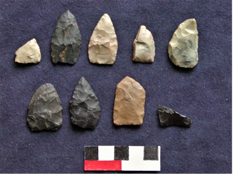
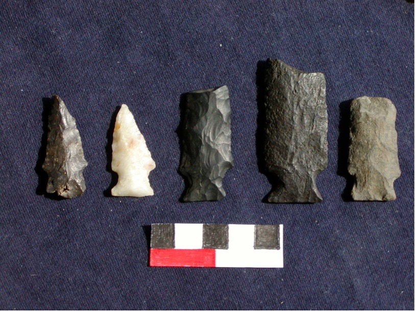
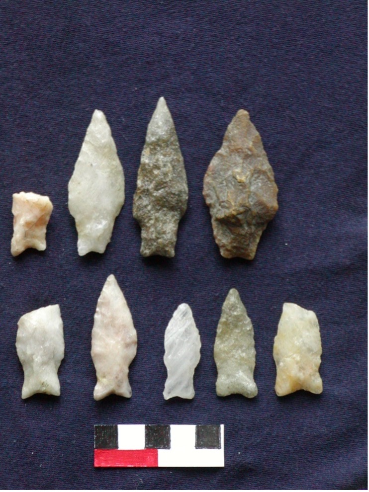
Untyped small lanceolate points; possible fluted point base at lower right
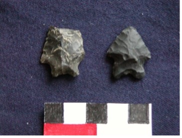
Kanawha bifurcate (left) and LeCroy bifurcate (right)
 />
/>
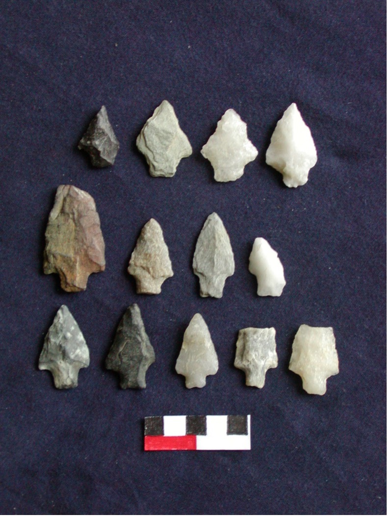
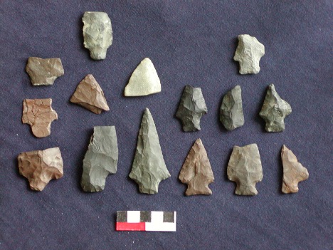
Neville and Neville-like points
Late Archaic Cultures: Ottter Creek, Brewerton, Narrow Stemmed
About 6000 rcbp (6800 to 6500 cal BP), large side-notched Otter Creek points began to spread across the Northeast, from the Upper Susquehanna (Funk 1993) to Maine (Sanger et al. 2007). This is culturally very significant because Funk (1993) interpreted this “Proto-Laurentian” development as the initiation of the region’s Late Archaic period. Otter Creek points may ultimately have been derived from the side-notched types of the mid-continent (e.g., Big Sandy, Raddatz). If there was a population expansion/migration from the Great Lakes to New England, it may have been a response to environmental changes around 7000 years ago. A widespread pollen transition is evident at 6800 cal BP (Gajewski et al. 2007). In New Jersey lake sediments, a sharp excursion in oxygen isotope ratios is observed at that time. In some Maine lakes, water level dropped to a stable minimum ca. 7200-5800 cal BP (Almquist et al. 2001), while an episode of severe storms is seen in lake sediments in New England at 6800 cal BP (Parris et al. 2009). Climate-related events are also observed in lake sediments in western New York at 7100 and 6600 cal BP (Ellis et al. 2004).
This Otter Creek point type and the affiliated Vergennes phase were originally defined on the basis of finds in western Vermont (Ritchie 1965:87). There, the Otter Creek points are associated with ground slate knives and ulus (crescent-shaped artifacts resembling the knives used by Inuit women). Ritchie also reported a copper gorge from the KI site. One of the slate points he illustrated (1965:Plate 27:2) is clearly imitative of a typical point form of the Old Copper Culture of the Great Lakes. A copper point of this type and other copper artifacts were found at the Sandy Lake Dam site, 21AK11, in northeastern Minnesota. A loosely associated piece of calcined bone was dated to 5690+-30 rcbp, or ca. 6500 cal BP (Bradford 2013). Organic materials adhering to Old Copper artifacts have been dated to 5940+-90, 4630+-60, 4590+-50, and 4420+-60 rcbp (6900 to 5000 cal BP) (Beukens et al. 1992). Chemical traces identified recently in Lake Superior sediments indicate that intensive copper mining occurred there between 6500 and 5400 cal BP (Pompeani et al. 2015).
Several Otter Creek occupations have been radiocarbon-dated in the mid- and upper Hudson Valley. At the Kingston Armory site in Ulster County, NY, three sequential components were identified: Vergennes (Otter Creek), Late Archaic (Vosburg), and Terminal Archaic (Snook Kill, River, Frost Island, and Orient phases). Radiocarbon dates for the Vergennes phase occupation are 6170+40 rcbp (7300-7000 cal BP) and 5820+40 rcbp (6700 cal BP) (Gould et al. 2008). Otter Creek points were found at Site 303 (also known as the Shafer site) on the Schoharie Creek floodplain near Breakabeen; they were associated with a radiocarbon date of 6290+-190 rcbp (ca. 7200 cal BP), which was obtained by combining charcoal from three hearths (Wellman 1996).
Otter Creek points are relatively rare in the Upper Delaware valley, occurring on only eight to 10 of the sites recorded by Kinsey (1972:408). They are also very sparsely distributed in southeastern New York. None have been found at the Marshlands Conservancy.
Otter Creek appears to have evolved into the Brewerton complex of side-notched, corner-notched, and eared points. William Ritchie (1965) regarded the Brewerton complex as part of a “Laurentian” tradition, while Dean Snow (1980) termed it the “Lake Forest Archaic.” Triangular points, not easily distinguished from much later Woodland arrow points, sometimes occur in association with Brewerton notched forms. The Brewerton complex dates to ca. 6000-4500 cal BP.
Ritchie found no datable charcoal at the type-sites of the Brewerton phase, Robinson and Oberlander No. 1. He was certain that this phase persisted as late as 4000 rcbp (4500 cal BP) in central New York, but he could not ascertain when it began. Subsequently, Funk (1993:190) reported a radiocarbon date of 5010+-30 rcbp (5770 cal BP) on scraps of bone from Burial 4 at Oberlander No. 1. Ritchie (1971a) supposed that Brewerton was coeval with the Vosburg phase of eastern New York. “The Brewerton culture, then, probably constituted the dominant, and probably the sole Late Archaic occupation of northern and north- central New York at around 2500 B.C., when the Lamoka culture flourished in the same role in south-central New York.” Charcoal from the Brewerton horizon at the base of the stratified O'Neil site in Cayuga County produced radiocarbon dates of 4000 ± 220 rcbp and 3960 ± 100 rcbp. A date of 3850 ± 95 rcbp was obtained on a sample of bone from Burial 78 on Frontenac Island, also in Cayuga County. The grave goods in this burial included a ground slate point and a chopper. The grave goods of the apparently contemporaneous adjacent Burial 79 included two stone plummets and a bird effigy comb made of bone. Ritchie (1971a) noted that a bird effigy comb had also been found in the Maritime Archaic cemetery at Port au Choix, Newfoundland, which dates to 4500-4000 cal BP. Hearth charcoal from Frontenac Island was dated to 3963 ± 80 and 3673 ± 250 rcbp. Ritchie believed a date of 4000 rcbp (4500 cal BP) was appropriate for the Frontenac phase, which he saw as a fusion of the Lamoka and Brewerton phases. Notably, Genesee points also were present in the Frontenac phase (Ritchie 1965: Plate 34), indicating some affiliation with Broadspear cultures that spread northward ca. 4000 cal BP.
Ritchie (1965: Plates 32 and 33) illustrated copper tools of Old Copper type, including a gouge or “spud,” a celt, and awls, from the Robinson site, and he noted that other copper tools had been found in the nearby plowed fields. Based on this it seems there must be some temporal overlap of the Brewerton phase with the peak production period of the Old Copper culture as inferred from the Lake Superior sediments (6500-5400 cal BP). This is consistent with the available radiocarbon dates.
Wall et al. (2003) identified typical Brewerton projectile points as well as other untyped projectile forms in association with a large and diverse cobble tool assemblage (although without a groundstone component) from the Mansfield Bridge Site (36Ti116) on the Tioga River near the New York-Pennsylvania border. Dates for features associated with this component ranged from 6600 to 6020 rcbp (7500-6800 cal BP) (Wall et al. 2003). These dates are anomalously old—earlier than some Otter Creek components. If accurate, they complicate the interpretation of Brewerton as derived from Otter Creek.
Points resembling the Brewerton side and corner-notched types were found on Morrison’s Island in the Ottawa River, between Ontario and Quebec. Twenty-four percent of these points were made of Onondaga chert from New York. This site included both campsite remains and intermingled burials. Copper was used to make diverse tools: barbs, awls, gorges, fishhooks and points. Two of the burials had pairs of copper bracelets. Radiocarbon dates for the burials are 4620+-40, 4630+-40 and 4860+-50 rcbp on human bone, and 4700+-150 rcbp on charcoal from a grave (Clermont and Chapdelaine 1998; Ellis et al. 2009). Taken together, these dates indicate a span from ca. 5600-5300 cal BP.
In the Hudson Valley, a distinctive local variant of the Brewerton corner-notched type is the Vosburg corner-notched point. At the Sylvan Lake Rockshelter, the Vosburg component dated to 4780+-80 rcbp (5500 cal BP) (Funk 1966). At the Kingston Armory site in Ulster County, the Vosburg phase occupation yielded radiocarbon dates of 4550+40 rcbp (5200 cal BP), 4520+40 rcbp (5200 cal BP), and 5130+40 rcbp (5800 cal BP) (Gould et al. 2008).
At the Camelot #2 site on the upper Susquehanna, Feature 22 was closely associated with three Brewerton eared triangles. Funk (1993:160 (vol. 1), 216 (vol. 2)) reports a date of 4795+-230 rcbp (ca. 5500 cal BP) for this feature, which also contained charred butternuts.
On the upper Delaware, the Faucett Site yielded radiocarbon dates for three stratified Late Archaic components (Kinsey 1972:398). A component lacking diagnostics dated to 6170±135 rcbp (I-5238). Above this, a Vosburg component dated to 5570±200 rcbp (I-5237) (ca. 6100-6600 cal BP). An overlying component contained a Brewerton eared-notched point, with a date of 5180±200 rcbp (Y-2479) (ca. 6300-5700 cal BP). The Lackawaxen component (with stemmed points) provided three dates: 4560±110, 4445±130, and 4130±180 rcbp (about 5300-4800 cal BP).
Triangular points, not easily distinguished from much later Woodland arrow points, sometimes occur in association with Brewerton notched forms. These triangles resemble the Archaic Beekman triangles from New York. Doucette (2005) describes “Snappit” triangles from Locus 4 at Annasnappet Pond. These were associated with features dated to 5100±40 and 5810±40 rcbp (ca. 6700 to 5700 cal BP). John Pfeiffer (1992) reports triangles from Brewerton sites in Connecticut: at the Arbucci Site an associated date was 4470±100 rcbp (ca. 5100 cal BP). At the Bliss Site in Old Lyme, Connecticut, Pfeiffer excavated 21 cremation burials that contained Brewerton eared triangular points, bannerstones, grooved axes, quartz crystals, sheet copper, red ochre, and mica. A dog or wolf had been buried alongside the humans. Pfeiffer obtained radiocarbon dates of 4280±85, 4535±95, and 4775±120 rcbp (ca. 5500 to 4800 cal BP). This Archaic cemetery was located only 30 meters (98 feet) west of the Griffin Site, where Terminal Archaic cremations were later interred between ca. 3500 and 3000 rcbp (3800 to 3200 cal BP). Given the proximity of these cemeteries and the similarities of burial customs, Pfeiffer argued for local cultural continuity between the Laurentian and Broadspear complexes. The 1,000-year gap that separated them cannot be ignored, however, particularly as the ubiquitous Small Stemmed Point occupation of New England falls precisely within that interval.
Between the Bliss and Griffin cemeteries lay the traces of three Laurentian dwellings indicated by postmolds (the Howard Site). One of these was fully excavated. It was oblong in shape, measuring about 10x5 meters. Associated hearths and refuse pits contained bones of deer and other mammals, birds, and fish, and also plant remains: hickory and walnut shells, acorns, and seeds of goosefoot (Chenopodium).
The disappearance of hemlock trees from the Northeastern forests—probably caused by climate changes between ca. 5800 and 5400 cal BP—opened the way for growth of a diverse understory and the florescence of northern hardwoods (Sanger et al. 2007). This new vegetation, combined with a possible reduction of snowfall, would have provided prime habitat for deer. Coeval with the hemlock decline there is a sudden, dramatic increase in radiocarbon dates associated with human occupation in New England and New York (Hoffman 1988, 1990; Reeve and Forgacs 1999; Fiedel 2001; Munoz et al. 2010). It is probably no coincidence that, around 5500-5000 cal BP, Lamoka and other, similar narrow stemmed points replaced notched points of the Brewerton tradition in New York, New England, and Quebec.
In Maine, Otter Creek points had appeared ca. 6500 cal BP (at the beginning of a regional thermal maximum); they disappeared ca. 5300 cal BP (Sanger et al. 2007). In Quebec, a “post-Laurentian” Lamoka-like complex, assumed to be intruders from the south, replaced the Laurentian Archaic culture at Pointe-du-Buisson ca. 4500 rcbp (5200 cal BP) (Chapdelaine 2000). Perhaps this Lamokoid expansion is a signal of southern deer hunters replacing northern moose hunters.
In southern New England, small stemmed points, generally made of quartz, are ubiquitous; in some areas they appear to represent a Late Archaic population peak that was never surpassed, as they are more numerous than diagnostic artifacts of later periods. At several sites, these points have been found in or near features dated to ca. 2300 rcbp or later (Hoffman 1990:197). These ostensibly late occurrences have been cited as evidence that this point type continued to be manufactured in New England into the Early and Middle Woodland periods. Some researchers also suggest that the attribution of all these stemmed points to the Late Archaic is largely responsible for the mistaken inference of a population decline in the Early Woodland (Juli 1999; McBride 1984). However, in central New York, where artifacts have been recovered from well-stratified sites in floodplain settings, stemmed points do not occur alongside or above the quite distinct point types of the Terminal Archaic period (ca. 4200 to 2900 cal BP) (Funk 1993).
Late Archaic people hunted deer and other animals of the deciduous forest (dominated by oak and chestnut, after the hemlock decline), collected nuts and seeds, and took fish and shellfish from the rivers. The predominant artifact in Late Archaic assemblages is the narrow stemmed point. This type, variously named in southeastern New York as “Taconic” (Brennan 1968) or “Sylvan Stemmed” (Funk 1976), dates from circa 4500 to 3500 rcbp (5300 to 3800 cal BP). A side-notched type (Sylvan Side-Notched or Twombly Side-Notched) apparently co-occurred with these stemmed points. In central New York, the narrow stemmed variant is known as Lamoka. At the Lamoka Lake Site in Schuyler County, dated to circa 4500 rcbp (5300 cal BP), hunting, fishing, and acorn-harvesting produced a sufficient resource base to support a semi-sedentary occupation by about 150 people; their prolonged occupation is indicated by a multitude of postmolds and numerous storage pits. On the Upper Delaware, the equivalent, contemporary type is known as Lackawaxen (Leslie 1967), with three sub-types: straight stem, expanded stem, and converging stem. A distinctive trait of Lackawaxen points is their raw material, which is frequently shale, argillaceous shale, or argillite.
On the Upper Susquehanna, Lamoka components were dated to between 4185±120 and 3750±100 rcbp (4800-4100 cal BP) at the Fortin Site, between 4490±90 and 3920±95 rcbp (5300-4300 cal BP) at Mattice No. 2, and have similar associated ages at other sites (Funk 1993:158-164). Vestal corner-notched and side-notched points, apparently contemporaneous with Lamoka, are very numerous in the area around Binghamton. Funk (1993:193), however, rejected many dates and argued that the “true” age of Vestal assemblages was ca. 3900-3800 rcbp (4300 cal BP), based on the stratigraphic superposition of Vestal above Lamoka components at several sites. Also partially contemporaneous or slightly later than Lamoka and Vestal (from about 3900 to 3700 rcbp [4400 to 4000 cal BP]) is the side-notched Normanskill point type, which was prevalent in the mid-Hudson, Susquehanna, and Mohawk valleys. Vestal points are not found in the Hudson Valley, but Normanskill points do appear are there.
The heaps of oyster shells (middens) along the eastern bank of the Lower Hudson River are mainly of Late Archaic age. Unfortunately, it is very difficult to interpret radiocarbon dates on shell, because of uncertainty about region-specific marine and freshwater reservoir effects. Because shellfish may ingest and incorporate old, 14C-depleted carbon from the surrounding water, shell samples generally yield radiocarbon ages that are much older than their true ages. The global average of the marine reservoir effect is about 400 years, but in some areas it is much greater, and it is not constant over time. Radiocarbon dates for Lower Hudson oysters are affected both by marine water in the tidal zone, and by limestone-derived carbon in the fresh water from upriver. Carbotte et al. (2004) dated oyster shells from submerged ancient natural beds north of the Tappan Zee Bridge. The oldest date they obtained was 6295+-45 rcbp. They applied a 950-year reservoir correction; thus, the age of this shell was calibrated as ca. 6100 cal BP.
The oldest human-harvested oyster shell on the Hudson came from the North Bowdoin Rockshelter, south of Poughkeepsie, dated to 7170+-200 rcbp. A Neville point was found nearby, which might indicate that the date is accurate and represents an episode of Middle Archaic oyster harvesting. However if a 950-year reservoir effect is applied, the calibrated age would be about 7000 cal BP—too recent to be associated with Neville points. To the south, the oldest shell date from the Dogan Point midden is 6950+-100 rcbp (ca. 6800 cal BP, reservoir-corrected). After that, dates in that area (near Croton-on-Hudson) jump forward to 5850 rcbp (5600 cal BP, reservoir-corrected), with a cluster of dates at Dogan Point in the range from 5650 to 5010 rcbp (5500-5400 cal BP, reservoir-corrected). There is a contemporaneous cluster of dates at Piping Rock (5325-4940 rcbp, 5000-4400 cal BP, reservoir-corrected) (Claassen 1995). Dated shells continue across the span from 4900 to 4400 rcbp (4500-3700 cal BP).
In Boston’s Back Bay, deeply buried remains of wooden fish weirs (designed to trap fish stranded by low tide) date between 5300 and 3700 rcbp (6000-4000 cal BP) (Decima and Dincauze 1998). Like the Lower Hudson middens, these dates suggest that Laurentian/Brewerton people were probably already taking fish and shellfish early as 7000 cal BP, but this practice was intensified by the Lamoka/Narrow Stemmed Point people after ca. 5300 cal BP.
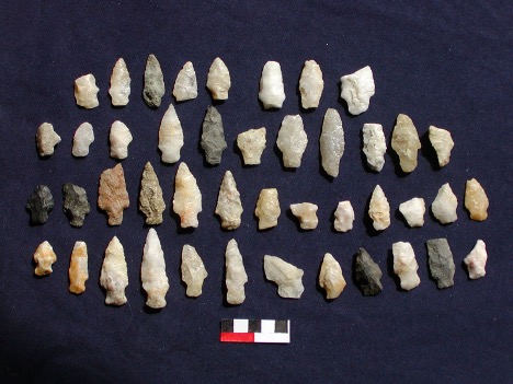
Late Archaic points found at the Marshlands include both Brewerton and Narrow Stemmed specimens. The Brewerton component consists of 5 Vosburg-like points, 17 Brewerton side- or corner-notched, 8 side-notched (Brewerton-like), and 2 Brewerton eared-notched (which resemble the much older Dalton-Hardaway type). The narrow stemmed points include 13 Lackawaxen, 15 Sylvan side-notched, 44 small Lamoka, Taconic or Wading River points, and 5 miniature stemmed points (perhaps toys or ritual objects).
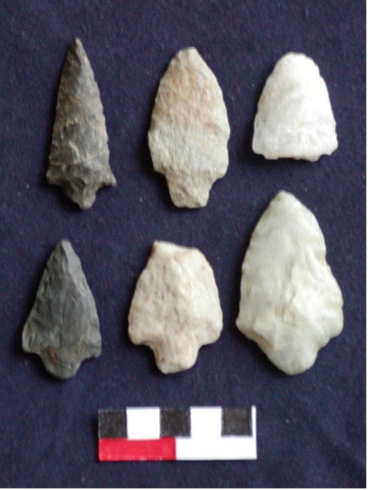
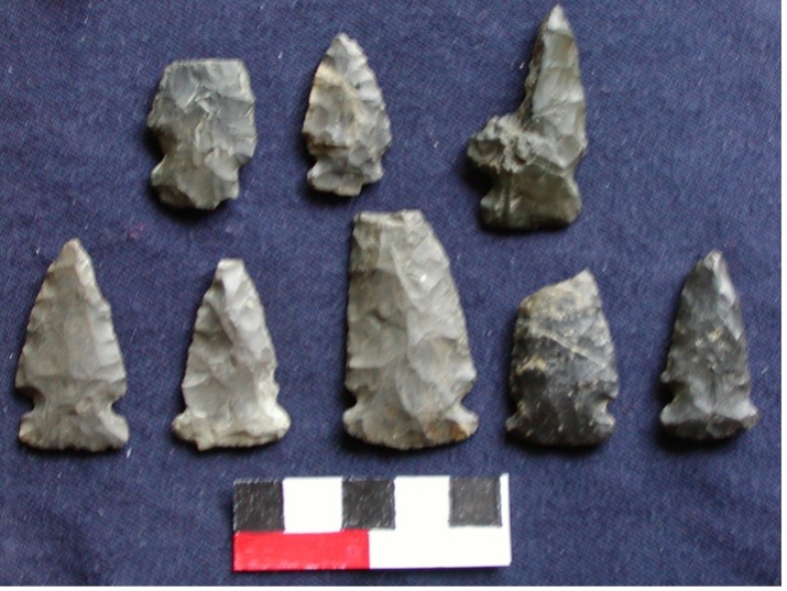
Stark or Morrow Mountain-like Points
Brewerton Side-notched points
Terminal Archaic (Transitional) Cultures: Broadspears and Fishtails
A centuries-long megadrought affected the interior of North America around 4200 cal BP (Booth et al. 2005), coincident with a Bond event (number 3) in the North Atlantic and the beginning of renewed expansion of mountain glaciers across the northern hemisphere. Perhaps in reaction to related environmental changes, Broadspear makers from the Southeast seem to have spread northward along the coastal plain, circa 4000 to 3500 rcbp (4500 to 3800 cal BP, 2500 to 1800 cal BC) (Kinsey 1972:359. There has been much debate regarding the nature of this expansion: was it a matter of indigenous residents adopting a useful new form of knife, or an entire intrusive cultural complex and immigrant population replacing the local peoples (e.g., Cook 1976; Custer 1991; Turnbaugh 1975)? Bourque (1995) makes a strong case for the Susquehanna Broadspear complex as an intrusive culture in northern New England.
The more northern broadspears seem to be derived from those of the Mill Branch culture, which had occupied the mid-Savannah River valley since 4700 cal BP. The Mill Branch people abandoned this homeland around 4200 cal BP (Sassaman 2006a), but they kept making their characteristic broadspears as they spread rapidly north through the Piedmont and Coastal Plain. As the broadspears spread, they replaced Late Archaic narrow stemmed points—probably also a signal of population replacement. In Georgia, the broadspears were made of rhyolite. In the Delaware Valley, lithic raw materials changed dramatically when the broadspears replaced the local narrow stemmed Lackawaxen points. The latter had been made of shale and argillite, but the preferred materials for broadspears are rhyolite, chert, and jasper. There does not appear to have been so radical a shift in the upper Hudson Valley, where chert continued to be used for broadspears.
The prototypical broad-bladed form, which spread as far north as Virginia and Maryland, is the Savannah River point. In Pennsylvania and New Jersey, these developed into Lehigh/Koens-Crispin points. At the Savich Farm, east of Philadelphia, dates of 3820+-60, 3640+-60, and 3530+-70 rcbp (4200-3700 cal BP) were obtained for graves containing Koens-Crispin points and winged bannerstones (atlatl weights) (Regensburg 1971, 1982). In New York, the earliest broad-bladed form is Snook Kill. In the Upper Susquehanna drainage, dates of 3830±80 and 3620±130 rcbp are associated with Snook Kill points (Funk 1993:162).
These squarish-stemmed early broadspears developed into the later Susquehanna, Wayland Notched (in southern New England) and Perkiomen points, with trowel-shaped blades, sharp shoulders, narrow waists, and fishtail-like bases (ca. 3900 to 3300 cal BP); these coeval types date to about 3600 to 3200 rcbp (3900-3400 cal BP). The last types in this series are Dry Brook (a narrower variant of the Susquehanna) and Orient Fishtail (3300 to 2900 cal BP), slimmer than its predecessors, with rounded shoulders. In southern New England the first phase is known as Atlantic, the second as Watertown, and the last as the Coburn phase (Dincauze 1972, 1975). The Watertown phase has been dated to 3470±125 rcbp at the Vincent site in Sudbury, Massachusetts; 3430±100 rcbp at the Flat River site in Washington, Rhode Island; and 3670±111 rcbp at the Litchfield Site in New Hampshire. Broadspear cremation burials at the Griffin Site in Connecticut dated between 3535±140 and 2985±70 rcbp (3800-3100 cal BP) (Pfeiffer 1980, 1992).
Four precise AMS dates for a hearth associated with Susquehanna and Dry Brook fishtail points and steatite bowl fragments at the Little Wood Creek site in Fort Edward, NY, are: 3160+-30, 3070+-30, 2970+-30, and 2980+-30 rcbp, or 3400-3100 cal BP (Grossman et al. 2015).
Tub-shaped, flat-bottomed bowls carved from soapstone (steatite) occur for the first time in association with Perkiomen or Susquehanna broadspears, both in the Upper Susquehanna and Upper Delaware drainages. In New England, soapstone vessels were first used in the Atlantic phase (ca. 3700 rcbp, 4000 cal BP [Sassaman 2006b]) but they became more numerous in the Watertown phase.
This carved stone vessel technology, interpreted as a step toward ceramic manufacture, was formerly seen as demarcating a “Transitional” cultural stage prior to the ceramic-producing Early Woodland cultures. Today, Terminal Archaic is the term more often applied to the period characterized by soapstone and broadspears. It has become evident that, in the Southeast, the manufacture of the first clay pots was contemporary with the soapstone vessels, not a derivative imitation (Sassaman 2006b). Nevertheless, the oldest ceramic pots in the Middle Atlantic region, called Marcey Creek ware, dating from ca. 3300 cal BP, were flat-bottomed like the steatite pots, and even included crushed bits of steatite as the tempering agent.
Broadspear occupations tend to be focused on river floodplains and levees. In the absence of organic remains, it is unclear if this tendency is primarily indicative of the importance of fish (and perhaps also seed-bearing plants and tubers) in the diet, or simply reflects the importance of rivers as transportation routes. An innovation associated with broadspears is the construction of large platform hearths or pavements, full of fire-cracked rock. Many of these were found in Level 3 of the Zimmermann site on the Upper Delaware (Werner 1972). Despite an absence of actual fish remains, it is generally assumed that these features were devoted to some kind of fish-processing, such as drying or smoking. This use would imply occupation sometime between March and June, when five species of shad migrate up the Delaware. Moeller (2005) notes a lack of diversity in the toolkits typically associated with these hearths and interprets this as indicative of short-term occupations rather than extended base-camps. He also suggests that the frequent burning of wood to heat the rock platforms may have severely diminished the local population of deciduous trees, causing an ecological catastrophe that led to the Early and Middle Woodland abandonment of the area. Whether or not this is a plausible explanation of local population dynamics, trans-regional climatic oscillations have been recognized, particularly at 2800 cal BP, which may have caused the apparent Early Woodland population collapse throughout much of the Northeast (Fiedel 2001).
Despite the evident concentration of sites in river valleys, broadspears are also found in interior, upland settings. This distribution complicates models that propose habitat partition as the basis for the presumed centuries-long coexistence in southern New England of stemmed point makers in the uplands and broadspear makers in the floodplains (e.g., Pagoulatos 1988; Pfeiffer 1992). Nevertheless, numerous radiocarbon-dated components do indicate that there was some temporal and spatial overlap of these traditions around 3700 rcbp (4000 cal BP). Dincauze (1975) suggested that the indigenous and intrusive traditions eventually coalesced, which would account for the narrow blades of Orient Fishtail points—the last type in the Broadspear sequence.
In the Delaware Valley there is good evidence of the stylistic evolution of Orient Fishtail points from broadspears, by way of the intermediate Dry Brook type. Orient Fishtail points (circa 3200 to 2700 rcbp, 3500 to 2800 cal BP) were found in elaborate mortuary deposits at the northeastern tip of Long Island, associated with carved soapstone bowls (Ritchie 1965). Ceramics, imitative of the soapstone (steatite) vessels in shape, are a minor part of Orient assemblages in the Upper Delaware Valley and eastern Long Island (Ritchie 1965:172); their appearance marks the onset of the Early Woodland. Marcey Creek steatite-tempered pottery was found in the Orient assemblage at Miller Field, New Jersey (dated to 3170±120 rcbp) (Kraft 1970). At the Faucett Site in the upper Delaware Valley, Exterior Corded/Interior Smoothed pottery appeared to be associated with an Orient component (Kinsey 1972:360).
Orient components are found at sites along the Hudson as far north as Saratoga County. At the stratified Coffin Site near Schuylerville, the Orient component yielded dates of 2820+-110 and 3040+-95 rcbp (Funk 1976:264). Orient points do not seem to occur farther west; they may overlap temporally with the Meadowood points that are predominant in central and western New York. Vinette 1 pottery, quartz-tempered, conical-shaped, and cordmarked on both exterior and interior surfaces, is frequently associated with Meadowood points and is the index trait for the beginning of the Early Woodland.
Among the small collection of Archaic projectile points found at the Throgs Neck midden site, Skinner (1919) depicted five broadspears and four Orient Fishtails. Surface finds at this location included five winged “bannerstones” resembling those found in the Broadspear graves at Savich farm.
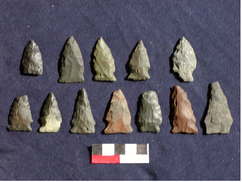
Relatively few broadspears have been found at the Rye Marshlands: 5 Snook Kill, 8 Susquehanna or Perkiomen points, and two untyped but broad tip fragments. Also noteworthy are 5 Normanskill-like side-notched points. This type dates to about 4400-3900 cal BP; the points bear some resemblance both to stemmed points but also to broadspears, with which they are partially contemporaneous.
In contrast, Orient Fishtails are by far the dominant component of the assemblage (264 artifacts in all, including fragments and preforms; of this total, 97 are whole or nearly complete points). Apart from the chipped stone artifacts, one piece of a soapstone bowl was also found. The Orient points can be sorted into seven distinct subsets based on the variable shapes of their bases. This variability does not seem to be correlated with the locations of their findspots along the shoreline. We cannot determine if these stylistic differences represent the habits of individual craftsmen or lineages, differing tool functions, or changes through time. However, the shouldered form, typeable as Dry Brook, is probably the earliest in the series.
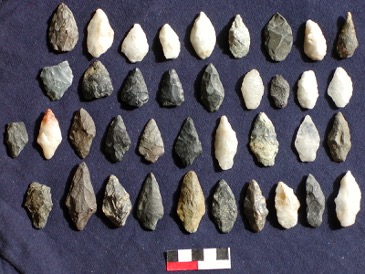
Narrow Stemmed Points (Taconic, Lamoka, Bare Island, Wading River, Sylvan)
Normanskill points
Broadspear points (Snook Kill, Atlantic, Susquehanna, Perkiomen)
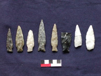
Orient Fishtail points
We can infer that the Orient Fishtail camp was not an ephemeral hunting or fishing site. The fishtail points were not merely resharpened here. All stages of manufacture are represented, from the split quartz cobble, through rough preforms, to the finished point. It is interesting that some very rough preforms, abandoned before they were thinned, already have a nearly finished fishtail base with a projecting spur. This probably indicates that the most fragile part of the point was chipped first. We don’t know why this base shape was so important; what was its special function?
Why was this location occupied so intensively between 3400 and 2900 cal BP? How does this relate to the ostensibly erratic sea level of this period and the following centuries?
Early Woodland Cultures
The temporal division between Terminal Archaic (without pottery) and Early Woodland (with pottery) has conventionally been set at 3000 rcbp (3200 cal BP). In the Middle Atlantic region, the earliest pottery seems to have imitated the soapstone bowls of the Broadspear tradition. The first pots of the Marcey Creek type, dated ca. 3300 cal BP, are shaped like the stone bowls and even contain crushed steatite pieces as temper. In the Northeast (north of New Jersey), however, the earliest ceramic vessels are not derived from the same tradition. These Vinette 1 pots are conical, thick-walled, grit-tempered, and cordmarked on both the exterior and interior surfaces. Their appearance marks the beginning of the Early Woodland period.
Most Orient Fishtail-associated radiocarbon dates, beginning about 3200 rcbp (3400 cal BP), fall on the early side of the Terminal Archaic/Early Woodland boundary (Fiedel 1988). However, a few dates are as late as ca. 2800 rcbp (2900 cal BP) (albeit with large standard errors). No credible Orient-associated dates are later than ca. 2750 rcbp (2850 cal BP, 880 cal BC). Orient points are associated with carved soapstone vessels, but also, rarely, with soapstone-tempered clay pots. Also, in rare instances, Orient points have been found in association with Vinette I potsherds. At the Kingston Armory site, for example, Vinette I sherds were recovered in association with a hearth that was dated to 2980+40 rcbp (ca. 3320-3060 cal BP). Orient Fishtail points also were found near this feature. Another date for this component is 2790+-40 rcbp (ca. 2950 cal BP) (Gould et al. 2008).
An in situ transition from Orient to the succeeding cultures has not been established. There is instead a sharp stylistic break, along with reduced numbers of recognizable and radiocarbon-dated Early Woodland components. Other than a real population collapse, the most plausible alternative explanation might be a period of severe riverine erosion that destroyed the relevant archaeological record. However, that would not explain the comparably small numbers of Early Woodland components in upland settings (Fiedel 2001).
Meadowood points are often associated with Vinette I pottery. Therefore, they are assigned unambiguously to the Early Woodland period. Radiocarbon dates for Meadowood generally fall between ca. 2900 and 2400 rcbp (3000-2500 cal BP); an anomalously early outlier from the Fortin site on the Upper Susquehanna is 3180+-95 (ca. 3300-3500 cal BP). Meadowood points seem to have developed from the small, notched points (e.g., of the Hind type) that are found in southern Ontario and the northern Midwest between ca. 3500 and 2800 rcbp (3800-2900 cal BP).
The Terminal Archaic/Early Woodland transition appears to be connected to an abrupt climate event. Numerous environmental records in Europe indicate a climatic downturn around 2750-2700 cal BP (800 to 750 cal BC), which coincides with a “cliff” in the radiocarbon calibration curve indicating weakened solar activity. Atmospheric 14C increases and radiocarbon dates drop abruptly from 2750 to 2450 rcbp (Fiedel 2001; Martin-Puertas et al. 2012; Van Geel and Mauquoy 2010). The “cliff” is followed by a plateau; between 2750 and 2400 cal BP, radiocarbon dates are indistinguishable, always ca. 2450 rcbp. Martin-Puertas et al. (2012) have shown that a simultaneous sharp increase in windiness and an increase in cosmogenic beryllium (10Be) occurred at ca. 2760 cal BP in central Europe; they infer that “changes in atmospheric circulation amplified the solar signal and caused abrupt climate change about 2800 years ago, coincident with a grand solar minimum.” This climate change coincides with Bond event 2 in the North Atlantic, and a probably associated climate episode shows up very strongly in the strontium/calcium ratios from Buckeye Creek Cave in West Virginia (Springer et al. 2008: Figure 1). At Cayuga Lake in central New York, Mullins et al. (2011) infer an abrupt cold, dry episode starting around 3000 cal BP and persisting to 2400 cal BP; they hypothesize it may have been caused by reduced solar activity. Pollen sampled from Ballston Lake, located between Saratoga and Schenectady, shows an increase of conifers, hardwoods, and boreal taxa at about 2680 cal BP (2520 rcbp); this is interpreted as marking a shift to colder climate (Toney et al. 2003). Shuman et al. (2009) infer the occurrence of a drought in eastern Massachusetts at ca. 2980 to 2760 cal BP, and Newby et al. (2011) infer a roughly contemporaneous drought (3500 to 2300 cal BP) in southwestern Massachusetts. All of these climate proxies may indicate the climatic stress responsible for the demise of the Broadspear tradition—i.e., the end of the Orient phase at ca. 2800 cal BP.
The period from about 2700 to 1700 rcbp (800 cal BC to cal AD 400) (Early Woodland and early Middle Woodland) is not well known. As Robert Funk observed, “Next to the Early Archaic this is the most poorly understood substage in the Northeast” and overall, “The evidence for this phase in New York State remains meager” (Funk 1993:200).”
Thin, side-notched Meadowood points, very different from Orient, are made usually of Onondaga chert from central/western New York, where this culture seems to have been centered. Radiocarbon dates for Meadowood range from ca. 3200 to 2300 rcbp. Meadowood points are thinly scattered across southern New England and do not seem to connote an established population; rather, they may represent transient traders or explorers seeking to acquire marine shells.
Small Meadowood habitation sites appear to be anomalously concentrated in a linear zone stretching from the Mohawk River to the upper Susquehanna (Taché 2011). This group includes Nahrwold 2 along Schoharie Creek (Ritchie and Funk 1973), where the small Meadowood component was dated to 2710+-80 rcbp.
Only eight Meadowood points have been found at the Marshlands Conservancy. Most appear to be made of Onondaga chert.
A more permanent occupation of northern New England by people tied to the Adena culture of the Ohio region is indicated by the Boucher cemetery, located on the Missisquoi River in Vermont (Heckenberger et al. 1990). Here, typical and remarkably well preserved Adena artifacts, as well as a Vinette 1 pot with unusual incised lines on the exterior, were recovered from 84 burial pits. Numerous radiocarbon dates place the graves within a long period from ca. 2700 to 2100 rcbp (with an older outlier at ca. 3000 rcbp).
In the Upper Delaware Valley there is sparse evidence of a fleeting presence of the Meadowood phase; at the Faucett Site, side-notched Meadowood points were stratified above the Orient component, and an associated radiocarbon date was 2700±100 rcbp (3000-2700 cal BP) (Kinsey 1972:361). A similarly ephemeral manifestation of the Adena complex of the Ohio region was discovered at the Rosencrans Site in Sussex County, New Jersey. The 13 cremation graves there contained blocked-end tubular pipes, slate gorgets, pendants, cones, slate and copper boatstones, a copper celt, copper beads, conch shell beads, Cresap stemmed points (an Ohio Valley type), and side-notched points. Associated radiocarbon dates were 2560±120 rcbp (Ritchie 1965:203) and 2400±60 rcbp (Kraft 1976).
As noted above, it may be the case that some surface finds of small stemmed points, attributed to the Late Archaic, actually date from the Early or even Middle Woodland; however, not only are the recognized point types of the period from ca. 2800-1700 cal BP (Meadowood, Adena, Rossville, and Lagoon) scarce, but so are Vinette potsherds. Setting aside diagnostic artifacts, even radiocarbon-dated components of this period are also relatively rare. If not a severe population downturn (as suggested by Fiedel 2001), the scarcity of sites in previously inhabited areas at least seems to indicate a dramatic change of settlement pattern, perhaps entailing aggregation in selected habitats.
In the coastal New York region, the Early Woodland phase has been called the North Beach Focus of the Windsor Aspect (Smith 1950). The grit-tempered pottery resembles Vinette I; loosely associated projectile point types include narrow stemmed, side-notched, Rossville, and Orient Fishtail.
In Connecticut, Vinette 1 pottery seems to co-occur with small stemmed points in the “Brodeur Point Phase” equivalent to Smith’s North Beach phase (McBride 1984).
Kinsey (1972) designated the seemingly indigenous Early to early Middle Woodland occupations of the Upper Delaware Valley as the “Bushkill complex,” with an estimated date range of 2500 to 2100 rcbp. Contracting-stemmed Rossville points are the most common diagnostic form of this period in the Upper Delaware Valley; Lagoon points and small numbers of nondescript side-notched forms were contemporaneous. Kinsey noted that the resemblance of Lagoon points to Adena forms is only superficial, and observed some similarity to Fox Creek/Steubenville points. The stone tools appear to have been associated with several pottery types (Vinette 1, Fabric-Impressed, Wiped, and Dentate-Stamped); however, the dominant ceramic type was Brodhead Net-Marked, a quartz-tempered ware that appears similar to the Popes Creek pottery of Virginia and Maryland as well as the North Beach type of coastal New York. Kinsey (1972:369) cautioned that the Bushkill complex seemed to be a grab-bag of distinct, incoherent traits: “…it is likely that too many projectile point and pottery types have been identified as traits for the complex to represent the original ethnological conditions. When additional information is derived from a satisfactory context, it may be possible to subdivide the present complex into several phases.”
At Teller’s Point (the south tip of Croton Point) on the lower Hudson, Fiedel (1991) excavated 27 Rossville points (16 of them, complete). Unfortunately, the points came from a mixed context, which also contained sherds of Vinette 1 and other (probably Middle Woodland) pottery, a few Orient points, and small stemmed points. At other Tappan Zee shell middens, there is a hiatus after 4365 rcbp, then dates of 3765 and 3750 rcbp from Piping Rock, followed by a long hiatus before dates of 2500 and 2200 rcbp at Dogan Point and 2480 rcbp at Piping Rock. These dates correlate quite closely with those reported for submerged oyster beds in the river (Carbotte et al. 2004). Those dates indicate an absence of oysters from ca. 3400 to 2800 cal BP (4200 to 3720 rcbp, without reservoir correction); then they recolonized the Hudson and thrived until about 900-500 cal BP. The unusual prevalence of Rossville points at Teller’s Point may reflect renewed harvesting of oysters after 2800 cal BP.
Rossville or similar points (including “Teardrop” points [Mounier and Martin 1994]), with convergent stems are very numerous at the Marshlands (107, including likely preforms). Their abundance here contrasts with their general scarcity in inland sites. Like the Orient Fishtails, the seemingly intensive Rossville occupation may be somehow related to the ca. 2800-1700 cal BP sea level anomaly.
Avocational collectors Wilbur and Glenn Clark and Frank Vetere found pottery at three sites within, and one site near, the Marshlands Conservancy. The pottery was analyzed by Lucianne Lavin and Birgit Morse (1985). At a site in the interior of the Conservancy, the Clarks excavated a small shell midden on a hilltop. Of the 28 sherds they found here, 24 were Vinette-like, with thick walls, grit temper, and cord-impressed exterior and interior surfaces. While these attributes suggest an Early Woodland age, 19 Late Woodland Levanna points were found in the same area.
Orient Fishtail points
Meadowood points
Middle Woodland Cultures
Fiedel (1987, 1991) observed that linguistic evidence indicated the fairly recent (less than 3,000-year) age of the Algonquian language family and placed its homeland north of Lake Ontario; this precluded an in situ Archaic ancestry of the New England Algonquian-speakers. Fiedel suggested that early Middle Woodland Point Peninsula pottery represented the initial expansion of Proto-Algonquians. Early Point Peninsula pottery, with complicated rocker- and dentate-stamped designs on exterior surfaces, was distributed across a vast expanse from Manitoba to the New England coast. Its expansion occurred between ca. 2400 and 1800 cal BP (400 cal BC-cal AD 200).
In Connecticut, after a poorly attested transition from the Brodeur Point/North Beach phase, the Roaring Brook phase (equivalent to the Middle Woodland Clearview phase of Smith (1950)) is characterized by rocker- or dentate-stamped pottery; the lithics now include more non-local materials. The settlement pattern changed; instead of the earlier seasonally occupied riverine and upland camps, sedentary villages were occupied in the river valleys. This shift may have been related to formation of resource-rich tidal marshes ca. cal AD 450 (Juli 1999). Lavin (1998) suggested that this phase, dated from ca. cal AD 300 to 750, represented the arrival of an intrusive population that came from the Middle Atlantic region. However, in view of the northern origin and expansion of Point Peninsula pottery, the rocker- and dentate-stamped pottery of the Clearview phase may instead denote the arrival of Algonquians in southern New England from the northwest, not from the Middle Atlantic.
In New York, Early Point Peninsula pottery is a marker of the Canoe Point phase (ca. 2200-1700 rcbp, 200 cal BC-cal AD 400). The pottery seem to be associated with crude, nondescript side-notched points. At the Cottage Site, a midden located on the Upper Susquehanna near Binghamton, an assemblage of this phase was dated to 1810±100 rcbp (Funk 1993:204). A later stage of the same cultural tradition seems to be represented at the Davenport Creamery Site, near Oneonta (Funk and Hoagland 1972b). Dentate and rocker-stamped sherds were associated with well-made, thin, side-notched points, resembling Ritchie’s (1971b) Long Bay type. A feature at the Creamery site was dated to 1625±95 rcbp. Apparently, Fox Creek points and Petalas “blades” (large bifaces) formed part of the same assemblage. Hart and Brumbach (2005) have recently reported dates from central New York, on organic residues adhering to sherds, that push back the date of Point Peninsula rocker-stamped pottery in that area: 2270±35, 2205±30, and 1620±35 rcbp.
Funk (1993) recognized a small (1 to 1.5 inches long) stemmed point type of the Middle Woodland period in the upper Susquehanna drainage; he referred to this type as “Sand Hill Stemmed.” At Harry’s Farm (Site 28Wa2) on the Upper Delaware, Kraft (1975a) excavated points of the Tocks Island type, in association with Abbott Horizontal Dentate, Brodhead Net-Marked, and Exterior Corded/Interior Smoothed pottery, and a radiocarbon date of 1660±95 rcbp. The corner- or side-notched Tocks Island points are restricted to that vicinity. A noteworthy feature at Harry’s Farm was a 47x26-foot platform of fire-cracked rock, which was surrounded by pits and hearths.
Two distinct and probably sequential Middle Woodland cultural complexes in southern New England are often conflated: Fox Creek and Jacks Reef/Kipp Island.
Fox Creek stemmed and lanceolate points were named by Robert Funk, based on examples he excavated from Stratum 3 of the Westheimer Site, at the confluence of Schoharie Creek and Fox Creek (Funk 1968). Avocational archaeologist Edward Kaeser called points equivalent to Funk’s Fox Creek type, “CONY” points (for “Coastal New York”). He found evidence of intensive CONY/Fox Creek occupation around Pelham Bay, only 17 km southwest of Rye (Kaeser 1968, 2004). It is surprising that, in sharp contrast, only 12 Fox Creek points have been found at the Marshlands.
The Fox Creek points at the Westheimer Site and at the Ford Site in Columbia County, NY (Funk 1976:131) were associated with net-marked potsherds. The same pottery was found at the Black Rock and Dennis sites on the Hudson. This component at Westheimer produced overlapping radiocarbon dates of 1500+-80 and 1540+-80 rcbp (ca. cal AD 500-530) (Ritchie and Funk 1973). A residue deposit on a Ford Netmarked sherd from Westheimer has been dated to 1600±35 rcbp (ca. cal AD 470) (Hart and Brumbach 2005). Both the Westheimer and Ford Site assemblages also included sherds of zoned-incised Abbott ware; this distinctive Middle Woodland type also has been found in New Jersey and coastal Virginia.
In coastal New York sites the pottery associated with Fox Creek points is often net-marked and shell-tempered, including Abbott-type incised sherds (Kaeser 1968, 2004). Net-marked pottery is also prevalent in the Bushkill phase on the Upper Delaware. In the lower Potomac drainage, the pottery associated with Fox Creek (a.k.a. Selby Bay points) is a shell-tempered ware called Mockley. In the areas fringing the Chesapeake Bay, Fox Creek/Selby Bay sites date as early as 2300 cal BP (Lowery, personal communication). Elsewhere, most dated components with Fox Creek points date to between ca. cal AD 300 and 700. This complex extended as far east as Martha’s Vineyard, where Fox Creek points (but no Abbott sherds) were found at the Cunningham Site in a component dated to 1550+-80 rcbp (Ritchie 1969).
The wide distribution of Abbott Zoned pottery shows that the Middle Woodland people of southern New York participated in a trade network that extended along the coastal plain from Maryland to Massachusetts. Fox Creek points also moved through this network. Many of these points were made of a reddish-purple argillite obtained near present-day Trenton, New Jersey.
This Fox Creek preference for argillite contrasts sharply with the lithic preference of the immediately succeeding (and perhaps partially coeval) Jack’s Reef complex (or Kipp Island Phase). Jack’s Reef corner-notched and pentagonal points are often made of Pennsylvania jasper, a material that is very rare or absent in Fox Creek lithic assemblages. The prevalence of jasper is evident in Jack’s Reef assemblages from Connecticut (Pfeiffer 1993). Unlike earlier points, which were used as spear or dart tips, Jack’s Reef points may have been used as arrow tips (Seeman 1992). From Maine to Illinois, they demarcate a late Middle Woodland horizon, the Kipp Island phase, dating from ca. cal AD 550 to 900 (Halsey 2013). Slightly older dates are reported from the Chesapeake region (Lowery 2013). Associated pottery types in New York include Point Peninsula Plain, Corded, and Rocker-Stamped; Jack’s Reef Corded and Corded Punctate; and Vinette Dentate. Radiocarbon dates on residues from Jack’s Reef Corded pottery in central New York are 1430±40, 1428±41, and 1315±50 rcbp (about cal AD 660) (Hart and Brumbach 2005). Clear differences from Fox Creek in lithic material preferences, associated ceramics, subsistence practices (Kipp Island has a strong emphasis on fishing), and site distributions suggest that Kipp Island represents a distinct, intrusive population in New England and the Middle Atlantic (Strauss 1993).
A particularly noteworthy find of late Middle Woodland age is a cremated burial on Minisink Island in the Upper Delaware (Ritchie 1965:234). The grave goods included “the calcined remains of a large, decorated comb of classic Kipp Island style, two perforated shark teeth, and a fragmentary straight-based platform pipe, all index markers for this phase.” These artifacts bespeak an obvious cultural relationship to the coeval Island Field cemetery in Delaware (Custer et al. and the cremated burial discovered beside the Whitehurst Freeway in Washington, D.C. (Knepper et al. 2006). Similar burials were found at Tottenville on Staten Island (Jacobson 1980) and at Taylor Hill on Cape Cod (Bradley 2008).
Only four Jack’s Reef points (two corner-notched and two pentagonal) have been found at the Marshlands Conservancy.
Rossville and Teardrop points
Late Woodland Cultures: Village Farmers
Archaeologists once believed that a commitment to horticulture was one of the main innovations that distinguished the Woodland from the preceding Archaic era. However, in this respect the Archaic/Woodland distinction has become very blurry as more data have accumulated that show, on the one hand, intensive plant-collecting and even cultivation at very early dates in the Archaic, and on the other, very limited reliance on cultigens of tropical origin until quite late in the Woodland era. Based upon his experience in the Hudson and Upper Susquehanna valleys, Robert Funk (1993:139) suggested that the whole cultural sequence from Early Archaic through Middle Woodland ought to be collectively lumped as a “Forager” stage of cultural development; Funk saw the transition from Middle to Late Woodland as the shift from this stage to the “Village Farmer” stage.
Several approximately coeval innovations mark the onset of the Late Woodland in southern New England ca. cal AD 1000: maize-based agriculture; permanent villages with storage facilities; the bow and arrow (signaled by triangular stone points of the Levanna and Madison styles); and globular-bodied, collared and incised pots manifesting Iroquoian stylistic influence. There has been much debate about how pervasive and disruptive the effects of maize adoption and village life were in southern New England and coastal New York. Several researchers have observed that there are few or no archaeological traces of nucleated villages in the region (e.g., Ceci 1979, Luedtke 1988). Chilton (2002) dismissed the adoption of maize as a “non-event,” but others (e.g., Petersen and Cowie 2002) have emphasized the ubiquitous evidence of maize and nucleated settlements after ca. cal AD 1300 and unambiguous Contact-era reports of relatively intense agriculture. Some Late Woodland/Contact villages at the heads of estuaries may have been rendered invisible by subsequent establishment of modern cities at the same favored locations. The Late Woodland population was sufficiently dense to sustain chiefdom-level polities in New England in the sixteenth and seventeenth centuries (Bragdon 1996). It is noteworthy, however, that surface finds of diagnostic triangular projectiles suggest that in many areas, the Late Woodland population was barely more numerous than that of the Late or Terminal Archaic.
In Connecticut, there is evidence that hazelnuts and cattails were gathered at the Sandy Hill Site by 9500 cal BP. A fragment of “gourd” (Cucurbita) rind recovered from the Sharrow Site in Maine was directly dated to 5695+-100 rcbp (about 6500 cal BP) (Petersen and Asch-Sidell 1996; Hart 2008). This plant has very bitter flesh, so it may have been grown and used for containers or fishing floats rather than consumed. Laurentian occupants of the Bliss-Howard Site in Connecticut were collecting goosefoot seeds (Chenopodium) around 5500 cal BP. Similar gathering of diverse plants by Archaic peoples of the mid-continent resulted in the coalescence by 3800 cal BP of an indigenous horticultural complex, recognized at the Riverton Site in Illinois. The cultivated plants of this complex included domesticated bottle gourd (Lagenaria siceraria), marshelder (Iva annua var. macrocarpa), sunflower (Helianthus annuus var. macrocarpus), and two cultivated varieties of chenopod (Chenopodium berlandieri), and possibly also Cucurbita pepo squash and little barley (Hordeum pusillum) (Smith and Yarnell 2009). However, there is no evidence that millennia of plant-gathering in the Northeast resulted in cultivation and sedentism prior to the adoption of maize.
John Hart’s project of radiocarbon-dating carbonized residues on sherds at the New York State Museum has produced a date of 2905+-35 rcbp for a sherd from the Scaccia Site, in Livingston County, that contains squash phytoliths. A sherd from the Vinette Site contains maize phytoliths in residue dated to 2270+-35 rcbp (Hart et al. 2003, 2007). Hart (2008) asserts that maize was common in central New York by ca. cal AD 500. It should be cautioned, however, that freshwater reservoir effects can make such residue dates too old by centuries (Fischer and Heinemeier 2003; Roper 2013; but see Hart and Lovis 2014).
There is no evidence that maize was a dietary staple in New England before ca. AD 1000. The oldest reported radiocarbon date for maize in New England appears to be from the Ingalls Site in New Hampshire: 960±30 rcbp (GX-30223), or ca. cal AD 1030 to 1150 (Chilton 2010; Hart 2008), although it seems that other maize samples from this site are appreciably younger. Surprisingly old maize, directly dated to 1210+-40 rcbp (cal AD 770-890) has been reported from the Deposit Airport I Site in Delaware County, New York (Knapp 2009). Site 211-1-1, located on Roeliff Jansen Kill, a small tributary on the east side of the Hudson River, was excavated as part of the Iroquois Pipeline survey (Cassedy and Webb 1999). A date of 810±50 rcbp was reported for maize, but corrected for 13C, this date should be 1050±50 rcbp or ca. cal AD 985. Hart has emphasized that beans spread into the Northeast much later than maize, but the temporal gap in New England is not great; a bean has been directly dated to 765 rcbp (cal AD 1275) at the Skitchewaug Site in the Connecticut River drainage in Vermont (Petersen and Cowie 2002).
About cal AD 900-1000 cordmarked pottery of the Owasco complex replaced the Point Peninsula types in New York. This marks the beginning of the Late Woodland period. In central New York, Owasco cultural development can be divided into three sequential phases, based mainly on ceramic style changes: Carpenter Brook (cal AD 1000 to 1200), Canandaigua (cal AD 1200 to 1275), and Castle Creek (cal AD 1275 to 1350) (Ritchie 1965:272; Snow 1980, 1995). Owasco vessels are less conical than Point Peninsula pots, but not as globular as later Iroquoian vessels. They had defined necks and flaring rims, and most were decorated with cord impressions around the neck. Collars, sometimes decorated with appliqued human effigies or incised designs, began to appear on Castle Creek phase pots. Stone and clay elbow pipes are also characteristic of Owasco.
The abruptness of the Point Peninsula/Owasco transition is debatable. Ritchie (1965) recognized a brief Hunter’s Home phase, transitional between Kipp Island and Owasco. Snow (1995) argued that there was an abrupt style change from Point Peninsula to Owasco, and that Hunter’s Home is an artificial construct attributable to assemblage mixing. He hypothesized that Owasco represents the intrusion of Proto-Iroquoians, migrants from a homeland somewhere in the Appalachian uplands. The Owasco economy, unlike their predecessors’, was committed to cultivation of maize and squash, (beans were a later addition to the diet, after AD 1300) supplemented by fishing, hunting, and gathering. Snow’s migration model was weakened by the discovery of maize in Princess Point complex sites in Ontario, dating to as early as AD 600 (Crawford and Smith 1996). As noted above, Hart et al. (2007) have reported even earlier dates for organic residues on ceramic sherds that contain maize phytoliths.
Princess Point ceramics are quite distinct from those of the Point Peninsula tradition and resemble Clemson’s Island pottery from Pennsylvania in some respects, such as the decoration of vessel necks with punctates. It may be that Princess Point and early Clemson’s Island actually represent the Iroquoian intrusion (as Fiedel [1991] suggested).
Particularly on the Upper Susquehanna, the Owasco culture’s close relationship to, and perhaps derivation from, the Clemson’s Island culture of central Pennsylvania is evident. This can be seen in the near identity of Clemson’s Island ceramics, dated to between AD 1000 and 1300, to types of the early Owasco Carpenter Brook phase (Stewart 1988:VIII-2). At the Deposit Airport Site located on the West Branch of the Delaware in Delaware County, NY, early Owasco and punctated Clemson’s Island sherds were recovered from the same features, dated to ca. 930 rcbp (ca. cal AD 1100) (Knapp 2009). At Smithfield Beach on the Upper Delaware, a date of ad 890±60 rcbp (ca. cal cal AD 1050-1150) was associated with Clemson’s Island Punctate sherds (Fischler and French 1991). A squash (Cucurbita) seed fragment was recovered from the same feature.
Owasco ceramics are associated with triangular points of the Levanna and, after AD 1100, Madison types, which were certainly arrowheads. Owasco assemblages also include a wide variety of bone and antler tools.
Because the geographic extension of particular styles of pottery decoration requires frequent face-to-face interactions between potters (almost certainly women in the Middle and Late Woodland Northeast), archeologists tend to assume that the distributional boundaries of recognized ceramic types roughly correspond to socio-linguistic entities. This assumption has led to a particularly thorny problem in the interpretation of Owasco. William Ritchie (1965) had originally, in the 1940s, accepted Arthur C. Parker’s identification of the Owasco culture as the material manifestation of Algonquian speakers; but as he later adopted the in situ theory of Iroquoian origins, he envisioned a gradual developmental continuum from Point Peninsula to Owasco to incipient Iroquois culture (e.g. Ritchie 1965:210). But this left the Munsee culture, which Ritchie investigated at the Bell-Philhower site on Minisink Island, unexplained:
“The Munsee division of the Lenni Lenape or Delaware Nation, of known Algonkian linguistic affiliation, were participants in the Owasco culture in a late prehistoric phase of their development. There seems to be no equally logical alternative to the judgment that Munsee culture, as it first appeared at their Minisink Island capital, conformed with the Castle Creek phase of the Owasco; that it underwent, prior to European impingement, progressive acculturation from neighboring groups, and from developing cultures upriver to the north which can historically be related to Iroquoian-speaking people.… Owasco culture was produced and shared by various groups whose linguistic affiliation included both Algonkians and Iroquoians” [Ritchie 1965:299].
The Algonquian and Iroquoian languages are radically distinct in all respects (phonology, grammar, and vocabulary); if they share a common ancestor, it can only be at great time depth, i.e., Paleoindian or Early Archaic.
There is a similar lack of fit of the ethnolinguistic and archaeological evidence in the Hudson drainage. When the Dutch arrived in the early 1600s, the lower Hudson was occupied by the Munsee, who spoke a distinct regional dialect of the Delaware language (a member of the Algonquian family) (Goddard 1978:213). Munsee speakers were divided into numerous social and political units (bands), but these formed a loose network, connected by kinship and marriage ties, that permitted frequent movement of individuals between bands. The Middle and Upper Hudson valley was occupied by the Mahican. They were not Delaware-speakers, but their Eastern Algonquian language was much more closely related to Delaware than to the Algonquian languages of the native peoples of New England. Nevertheless, as Funk (1976:311) observed, in the Hudson Valley “the fragmentary data for post-Owasco manifestations leave little doubt that there was an unbroken development into ceramic stages similar to the Oak Hill, Chance, and Garoga horizons of the Mohawk Iroquois.”
At the time of European contact, a sharp linguistic boundary, which closely corresponded to the present New York/Connecticut line, separated the Munsee of Westchester from the Algonquian-speaking peoples of southern New England. This boundary also stretched across the Sound; the natives of eastern Long Island were linguistic kin of the Connecticut groups, while the inhabitants of westernmost Long Island (the Canarsee and Rockaway) spoke Munsee. The section of the island opposite Rye was occupied by the Matinecock and Massapequa, who may not have been Munsee-speakers (Goddard 1978).
Herbert Kraft (1975b), well aware of the linguistic problem, attempted to define a regionally specific variant of Owasco on the Upper Delaware, ancestral to the Munsee; he called it “Pahaquarra,” and contended that it could be distinguished from New York Owasco on five criteria. However, a subsequent re-evaluation of the regional Late Woodland sequence (Williams et al. 1982) concluded that Pahaquarra was not really different from Owasco. Most recently, Hart and Brumbach (2003) have argued that Owasco is a miscellaneous hodgepodge of unrelated traits that should not have been regarded as a coherent, temporally and spatially bounded cultural entity in the first place.
The complete correspondence of presumably ancestral Munsee ceramics to Iroquoian, and specifically Mohawk types, continues through the post-Owasco period, when Upper Delaware types are variations on Chance Incised pottery. Kinsey (1972:393) remarked, “In brief, there is the ambiguity of Iroquoian-speaking and Algonquian-speaking Indians possessing an identical ceramic tradition. This is not what we would expect, and it is regarded as an important and unresolved Late Woodland problem.”
The earliest Owasco pottery types in central New York are Wickham Corded Punctate, Carpenter Brook Cord-on-Cord, Levanna Cord-on-Cord, and Canandaigua Plain. The generally accepted ages of the successive Owasco phases are cal AD 1150-1200 for Carpenter Brook, cal AD 1200-1275 for Canandaigua, and cal AD 1275-1350 for Castle Creek. However, recently reported dates on residues suggest that some Owasco types may be substantially older than previously thought, although possible reservoir effects should be borne in mind. New dates for Wickham Corded Punctate are 1425±45, 1260±39, and 1228±42 rcbp. Carpenter Brook Cord-on-Cord sherds have been dated to 1470±43, 1247±48, and 1231±44 rcbp (about cal AD 700) (Hart and Brumbach 2005). Sackett Corded is dated to 810±150 rcbp at the Sackett Site in central New York. Sackett Corded is the predominant middle and late Owasco type; it encompasses Owasco Corded Horizontal, Owasco Herringbone, Owasco Platted, and Owasco Corded Oblique variants (Kinsey 1972:380). Hart and Brumbach (2005) have reported residue dates of 1211±46 rcbp (ca. cal AD 750) for Owasco Corded Horizontal and 781±42 rcbp (cal AD 1250) for Owasco Corded Oblique. On Minisink Island, Sackett Corded and Levanna Cord-on-Cord sherds were dated to 730±50 rcbp (Kraft 1978).
The transition from Owasco into a recognizable proto-Mohawk culture occurred during the Oak Hill phase (AD 1350-1400) in central New York. During the following Chance phase (AD 1400-1525), ancestral Mohawk moved into nucleated, fortified villages. Their characteristic Chance Incised pottery was decorated with alternate triangular plats and oblique lines. Deowongo Incised, Durfee Underlined, and Garoga Incised are recognized on the basis of slight design elaborations on the Chance prototype. The culture of the protohistoric Mohawk is ascribed to the Garoga phase (1525-1550).
Ritchie (1965), following Smith (1950), defined two Late Woodland cultural traditions in southeastern NY, based mainly on pottery styles: Windsor and East River. Smith thought the East River tradition was intrusive, and it is tempting to equate its material culture with the distinctive Munsee linguistic entity, which did not supplant the ostensibly older Algonquian languages of eastern Long Island. In the latter region the Sebonac phase of the Windsor tradition is represented at the Wells, Old Field A and B, Aquebogue, Sebonac, Squaw Cove, and Soak Hides sites, and in Connecticut, at the Old Lyme, South Woodstock, and Niantic sites. Smith also recognized a later stage of the Windsor tradition, called the “Niantic Focus.” The usual temper of Sebonac pots was crushed shell, or rarely, grit. External surfaces were brushed or wiped, or plain, or fabric- or cord-marked. Interiors were smoothed, brushed, or scraped. The area from the shoulder to the lip was often decorated, using a scallop shell to create simple linear, crisscross, or triangular designs.
The Bowmans Brook phase of the East River Tradition, recognized in Manhattan, Westchester and Rockland counties, and western Long Island, was evidently related to, and perhaps derived from, Late Woodland cultures of New Jersey; this is what we would expect if it was the material culture of Munsee-speakers. The type site for which this phase was named was on Staten Island. Related components were recognized at the Grantville B and Wilkins sites on western Long Island. Although no radiocarbon dates were obtained for Bowmans Brook, Ritchie (1965) thought Smith (1950) had correctly placed the beginning of the phase around AD 1100. Bowmans Brook pots include two main varieties, stamped and incised. Ritchie observed the similarity of Bowmans Brook pottery to the Abbott Zoned Incised type of New Jersey and Overpeck Incised type of eastern Pennsylvania. However, Abbott Zoned Incised is now recognized as a late Middle Woodland ware, dated roughly to cal AD 200-800, which was also made and used by people in the Virginia coastal plain.
The Clasons Point phase developed perhaps ca. AD 1300 (no radiocarbon dates confirm this) from Bowmans Brook; this culture extended from western Long Island to the Hudson Highlands. Sites of this phase include the Helicker’s Cave and Finch’s Rock House rockshelters in Armonk (Harrington 1909), and the type site (for which it was named) in the eastern Bronx. Clasons Point was contemporaneous with, and influenced by, late Owasco and early Iroquois, and lasted into the early Contact period in the 1600s. The earlier pots are more often tempered with shell than grit, generally had no collars, and were cord-impressed. Later pots are globular, with rounded bases, everted and collared rims, and the collars may be cord-impressed or incised. The cord-impressed variety, called Van Cortlandt Stamped, is very similar to Owasco Corded Collar ware. The incised-collar variety, Eastern Incised, resembles the Iroquoian-made Chance Incised and Deowongo Incised types of upstate New York. Like the Late Woodland and proto-historic pottery of the Upper Delaware, both the Windsor and East River ceramic traditions presumably represent the material culture of Algonquian-speakers who were strongly influenced by nearby Iroquoian-speakers.
Most of the pottery found by the Clarks in and near the Marshlands Conservancy dates to the Late Woodland. Sherds of 12 typeable vessels were identified (Lavin and Morse 1985). They mainly represent styles of the early Clasons Point phase. A pot from a rockshelter (Site #3) is of the Milo Corded type first recognized at a site in Pelham Bay Park in the Bronx (Lopez 1958:133). The same type also is reported from northern New Jersey sites (Kinsey 1972:465; Kraft 1975b:118). Another pot from the nearby shell midden at Site #3 also was assigned to the same type, which closely resembles East River Cordmarked. Another sherd lot from the midden represents a different vessel that was shell tempered, with a scallop-shell-stamped exterior; this was typed as Sebonac Stamped. A shell-tempered rim sherd from the midden, decorated with fine parallel incised lines, was classified as Bowmans Brook Incised or Eastern Incised.
At the Sherman site, located near Blind Brook northeast of the Conservancy, a flexed adult male burial was discovered accidentally and salvaged in 1972. The burial pit contained 55 potsherds; another nine were found nearby. The sherds in the burial pit represented two vessels: 51 sherds of an Owasco Corded Horizontal pot, and four sherds of a miniature pot. The latter could be typed as either Owasco Corded Horizontal or Bowmans Brook Stamped. A midden area near the burial contained lithic debitage and nine sherds. The sherds represent six different pots. Two grit-tempered, near-rim sherds had an incised herringbone design (#1 in the photo). Both this vessel and three represented by the other sherds, were typed as Bowmans Brook Incised. One sherd (#5 in the photo) was typed as either Van Cortlandt Stamped or the equivalent type in the upper Delaware Valley, Kelso Corded Variant (Kraft 1975b). Three sherds of a single pot (#6 in the photo) with shell temper, a brushed interior surface, and smoothed-over cordmarking on the exterior, could not be attributed to a particular type; it seems to combine East River and Windsor techniques (Lavin and Morse 1985). Overall, this small collection of pottery is congruent with the linguistic evidence of the relationship of the pre-Contact people of this area to the Munsee-speakers of northern New Jersey and the lower Hudson region.
In the shoreline collection from the Marshlands Conservancy, 31 finished triangular points are confidently classified as Late Woodland Levanna points. Another 25 relatively crude points may be unfinished Levanna preforms, or they might be Archaic triangles. Five points are elongated triangles that are probably a functional variant (knives?) of the Levanna type.
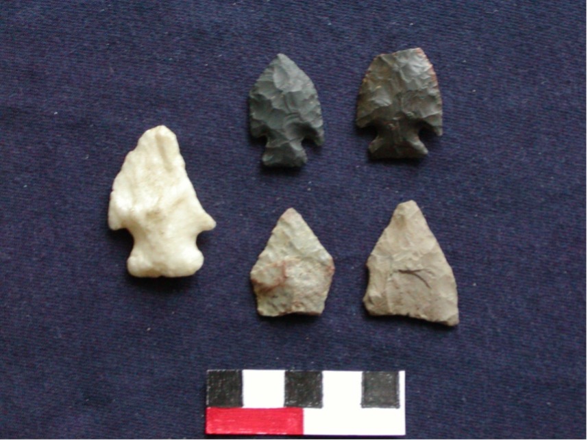
Jack’s Reef corner-notched and pentagonal points. These were possibly arrow tips.
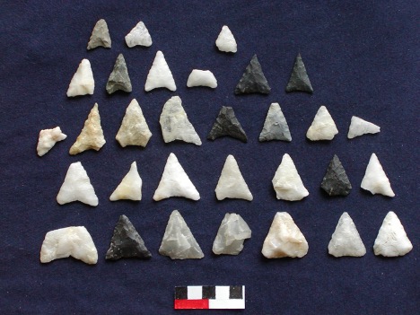
Levanna triangle points (probably arrow tips)

Sherds from Blind Brook site; above, from burial; below, from shell midden (Lavin and Morse 1985